Mouchamps geodata
Mouchamps (Pays de la Loire) is a populated place; located in France in Europe/Paris (GMT+2) time zone. With population of 2,628 people, there are 3710 cities with bigger population in this country. Compared to other cities in France, 57.4% of cities are located further ↑North; 88.8% of cities are located further →East and 60.8% of cities have higher elevation than Mouchamps. Note1
Administrative division(s):
- Level 1: Pays de la Loire
- Level 2: Département de la Vendée
- Level 3: Arrondissement de La Roche-sur-Yon
- Level 4: Mouchamps


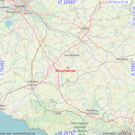
Mouchamps GPS coordinates[2]
46° 46' 52.716" North, 1° 3' 42.444" West
| Map corner | latitude | longitude |
|---|---|---|
| Upper-left | 47.26065°, | -1.76492° |
| Center: | 46.78131°, | -1.06179° |
| Lower-right: | 46.29767°, | -0.35867° |
| Map W x H: | 107.1×107.1 km | = 66.5×66.5mi |
| max Lat: | 51.07786° ⇑57.4% North |
| Mouchamps: | 46.78131° |
| min Lat: | ⇓42.6% South 41.3874° |
| min Long | Mouchamps | max Long |
| -5.08615° | -1.06179° | 9.52242° |
| W 11.2%⇐ | ⇒88.8% E |
Elevation
Elevation of Mouchamps is 100 m = 328 ft, and this is 93.7 m = 307 ft below average elevation for this country.
| Max E: |
2333 m = 7654 ft | 60.8% |
| Avg. | 193.7 m = 635 ft | |
| Mouchamps | 100 m = 328 ft | |
Min E: |
-1 m = -3 ft | 39.2% |
See also: France elevation on elevation.city.
Geographical zone
Mouchamps is located in North temperate zone (between Tropic of Cancer and the Arctic Circle). Distance of this North polar circle is 2199.6 km =1366.8 mi to North.| Distance of | km | miles | from Mouchamps |
|---|---|---|---|
| North Pole | 4805.5 | 2986 | to North |
| Arctic Circle | 2199.6 | 1366.8 | to North |
| Tropic Cancer | 2595.7 | 1612.9 | to South |
| Equator | 5201.6 | 3232.1 | to South |


Nearby cities:
15 places around Mouchamps: (largest is in red/bold)
• Chantonnay
10.5 km =6.5 mi,  175°
175°
• Le Boupère
10.4 km =6.5 mi,  81°
81°
• Les Herbiers
10.1 km =6.3 mi,  19°
19°
• Mesnard-la-Barotière
9 km =5.6 mi,  341°
341°
• Monsireigne
9.5 km =5.9 mi,  115°
115°
• Rochetrejoux
5.1 km =3.2 mi, 79°
• Saint-Germain-de-Prinçay
7.4 km =4.6 mi,  155°
155°
• Saint-Martin-des-Noyers
11 km =6.8 mi,  233°
233°
• Saint-Paul-en-Pareds
7.1 km =4.4 mi,  50°
50°
• Saint-Prouant
8.4 km =5.2 mi,  107°
107°
• Saint-Vincent-Sterlanges
5 km =3.1 mi,  203°
203°
• Sainte-Cécile
5.9 km =3.7 mi,  223°
223°
• Sainte-Florence
7.2 km =4.5 mi,  283°
283°
• Sigournais
10.1 km =6.3 mi,  145°
145°
• Vendrennes
6.8 km =4.2 mi,  316°
316°
Sources, notices
• [Note1] Compared only with cities in France existing in our database
• [Src1] Map data: © OpenStreetMap contributors (CC-BY-SA)
• [Src2] Other city data from geonames.org with taken over terms of usage.
• [Src3] Geographical zone / Annual Mean Temperature by Robert A. Rohde @ Wikipedia
