Sainte-Croix-Volvestre geodata
Sainte-Croix-Volvestre (Occitanie) is a populated place; located in France in Europe/Paris (GMT+2) time zone. With population of 643 people, there are 12632 cities with bigger population in this country. Compared to other cities in France, 97.7% of cities are located further ↑North; 67.2% of cities are located further →East and 86.9% of cities have lower elevation than Sainte-Croix-Volvestre. Note1
Administrative division(s):
- Level 1: Occitanie
- Level 2: Département de l'Ariège
- Level 3: Arrondissement de Saint-Girons
- Level 4: Sainte-Croix-Volvestre
Current local time in Sainte-Croix-Volvestre:
11:33 PM, SaturdayDifference from your time zone: hours


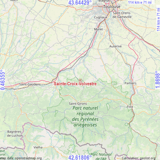
Sainte-Croix-Volvestre GPS coordinates[2]
43° 7' 59.988" North, 1° 10' 0.012" East
| Map corner | latitude | longitude |
|---|---|---|
| Upper-left | 43.64429°, | 0.46355° |
| Center: | 43.13333°, | 1.16667° |
| Lower-right: | 42.61806°, | 1.8698° |
| Map W x H: | 114.1×114.1 km | = 70.9×70.9mi |
| max Lat: | 51.07786° ⇑97.7% North |
| Sainte-Croix-Volvestre: | 43.13333° |
| min Lat: | ⇓2.3% South 41.3874° |
| min Long | Sainte-Croix-Vo | max Long |
| -5.08615° | 1.16667° | 9.52242° |
| W 32.8%⇐ | ⇒67.2% E |
Elevation
Elevation of Sainte-Croix-Volvestre is 372 m = 1220 ft, and this is 178.3 m = 585 ft above average elevation for this country.
| Max E: |
2333 m = 7654 ft | 13.1% |
| Sainte-Croix-Volvestre | 372 m 1220 ft | |
| Avg. | 193.7 m = 635 ft | |
Min E: |
-1 m = -3 ft | 86.9% |
See also: France elevation on elevation.city.
Geographical zone
Sainte-Croix-Volvestre is located in North temperate zone (between Tropic of Cancer and the Arctic Circle). Distance of this Northern Tropic circle is 2190.1 km =1360.9 mi to South.| Distance of | km | miles | from Sainte-Croix-Volvestre |
|---|---|---|---|
| North Pole | 5211.1 | 3238 | to North |
| Arctic Circle | 2605.2 | 1618.8 | to North |
| Tropic Cancer | 2190.1 | 1360.9 | to South |
| Equator | 4796 | 2980.1 | to South |


Nearby cities:
15 places around Sainte-Croix-Volvestre: (largest is in red/bold)
• Boussens
16.5 km =10.3 mi,  286°
286°
• Cassagne
14.4 km =8.9 mi,  264°
264°
• Cazères
10.5 km =6.5 mi,  321°
321°
• Daumazan-sur-Arize
11.4 km =7.1 mi,  84°
84°
• Lavelanet-de-Comminges
14.1 km =8.8 mi,  343°
343°
• Martres-Tolosane
14.6 km =9.1 mi,  300°
300°
• Mondavezan
15.8 km =9.8 mi, 318°
• Montesquieu-Volvestre
9.6 km =6 mi,  31°
31°
• Montjoie-en-Couserans
14.6 km =9.1 mi,  182°
182°
• Palaminy
11.2 km =7 mi,  313°
313°
• Prat-Bonrepaux
16.5 km =10.3 mi,  227°
227°
• Rieux-Volvestre
13.3 km =8.3 mi,  11°
11°
• Roquefort-sur-Garonne
15.9 km =9.9 mi,  281°
281°
• Saint-Lizier
14.8 km =9.2 mi,  189°
189°
• Saint-Élix-le-Château
16.5 km =10.3 mi,  351°
351°
Sources, notices
• [Note1] Compared only with cities in France existing in our database
• [Src1] Map data: © OpenStreetMap contributors (CC-BY-SA)
• [Src2] Other city data from geonames.org with taken over terms of usage.
• [Src3] Geographical zone / Annual Mean Temperature by Robert A. Rohde @ Wikipedia
