Sainte-Catherine-de-Fierbois geodata
Sainte-Catherine-de-Fierbois (Centre) is a populated place; located in France in Europe/Paris (GMT+2) time zone. With population of 644 people, there are 12610 cities with bigger population in this country. Compared to other cities in France, 53.5% of cities are located further ↑North; 71.8% of cities are located further →East and 56.5% of cities have higher elevation than Sainte-Catherine-de-Fierbois. Note1
Administrative division(s):
- Level 1: Centre
- Level 2: Département d'Indre-et-Loire
- Level 3: Arrondissement de Tours
- Level 4: Sainte-Catherine-de-Fierbois
Current local time in Sainte-Catherine-de-Fierbois:
11:25 AM, SaturdayDifference from your time zone: hours


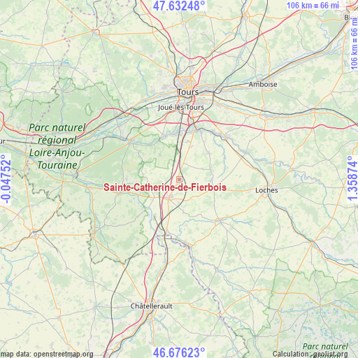
Sainte-Catherine-de-Fierbois GPS coordinates[2]
47° 9' 23.436" North, 0° 39' 20.196" East
| Map corner | latitude | longitude |
|---|---|---|
| Upper-left | 47.63248°, | -0.04752° |
| Center: | 47.15651°, | 0.65561° |
| Lower-right: | 46.67623°, | 1.35874° |
| Map W x H: | 106.3×106.3 km | = 66.1×66.1mi |
| max Lat: | 51.07786° ⇑53.5% North |
| Sainte-Catherine-de-Fierbois: | 47.15651° |
| min Lat: | ⇓46.5% South 41.3874° |
| min Long | Sainte-Catherin | max Long |
| -5.08615° | 0.65561° | 9.52242° |
| W 28.2%⇐ | ⇒71.8% E |
Elevation
Elevation of Sainte-Catherine-de-Fierbois is 112 m = 367 ft, and this is 81.7 m = 268 ft below average elevation for this country.
| Max E: |
2333 m = 7654 ft | 56.5% |
| Avg. | 193.7 m = 635 ft | |
| Sainte-Catherine-de-Fierbois | 112 m = 367 ft | |
Min E: |
-1 m = -3 ft | 43.5% |
See also: France elevation on elevation.city.
Geographical zone
Sainte-Catherine-de-Fierbois is located in North temperate zone (between Tropic of Cancer and the Arctic Circle). Distance of this North polar circle is 2157.9 km =1340.9 mi to North.| Distance of | km | miles | from Sainte-Catherine-de-Fierbois |
|---|---|---|---|
| North Pole | 4763.7 | 2960 | to North |
| Arctic Circle | 2157.9 | 1340.9 | to North |
| Tropic Cancer | 2637.4 | 1638.8 | to South |
| Equator | 5243.3 | 3258 | to South |


Nearby cities:
15 places around Sainte-Catherine-de-Fierbois: (largest is in red/bold)
• Draché
11.5 km =7.1 mi,  191°
191°
• La Chapelle-Blanche-Saint-Martin
13 km =8.1 mi,  127°
127°
• Louans
7.6 km =4.7 mi,  65°
65°
• Maillé
12.7 km =7.9 mi,  205°
205°
• Manthelan
10.6 km =6.6 mi,  102°
102°
• Noyant-de-Touraine
8.9 km =5.5 mi,  234°
234°
• Pont-de-Ruan
13.2 km =8.2 mi,  332°
332°
• Pouzay
12.4 km =7.7 mi, 228°
• Saché
13.1 km =8.1 mi,  320°
320°
• Saint-Branchs
11.8 km =7.3 mi,  48°
48°
• Saint-Épain
9.1 km =5.7 mi,  261°
261°
• Sainte-Maure-de-Touraine
5.6 km =3.5 mi, 206°
• Sorigny
10.1 km =6.3 mi,  17°
17°
• Thilouze
9.5 km =5.9 mi, 322°
• Villeperdue
5.3 km =3.3 mi,  342°
342°
Sources, notices
• [Note1] Compared only with cities in France existing in our database
• [Src1] Map data: © OpenStreetMap contributors (CC-BY-SA)
• [Src2] Other city data from geonames.org with taken over terms of usage.
• [Src3] Geographical zone / Annual Mean Temperature by Robert A. Rohde @ Wikipedia
