Draché geodata
Draché (Centre) is a populated place; located in France in Europe/Paris (GMT+2) time zone. With population of 669 people, there are 12229 cities with bigger population in this country. Compared to other cities in France, 54.7% of cities are located further ↑North; 72.1% of cities are located further →East and 77.8% of cities have higher elevation than Draché. Note1
Administrative division(s):
- Level 1: Centre
- Level 2: Département d'Indre-et-Loire
- Level 3: Arrondissement de Loches
- Level 4: Draché


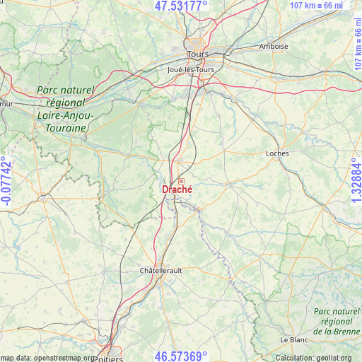
Draché GPS coordinates[2]
47° 3' 17.568" North, 0° 37' 32.556" East
| Map corner | latitude | longitude |
|---|---|---|
| Upper-left | 47.53177°, | -0.07742° |
| Center: | 47.05488°, | 0.62571° |
| Lower-right: | 46.57369°, | 1.32884° |
| Map W x H: | 106.5×106.5 km | = 66.2×66.2mi |
| max Lat: | 51.07786° ⇑54.7% North |
| Draché: | 47.05488° |
| min Lat: | ⇓45.3% South 41.3874° |
| min Long | Draché | max Long |
| -5.08615° | 0.62571° | 9.52242° |
| W 27.9%⇐ | ⇒72.1% E |
Elevation
Elevation of Draché is 60 m = 197 ft, and this is 133.7 m = 439 ft below average elevation for this country.
| Max E: |
2333 m = 7654 ft | 77.8% |
| Avg. | 193.7 m = 635 ft | |
| Draché | 60 m = 197 ft | |
Min E: |
-1 m = -3 ft | 22.2% |
See also: France elevation on elevation.city.
Geographical zone
Draché is located in North temperate zone (between Tropic of Cancer and the Arctic Circle). Distance of this North polar circle is 2169.2 km =1347.9 mi to North.| Distance of | km | miles | from Draché |
|---|---|---|---|
| North Pole | 4775 | 2967 | to North |
| Arctic Circle | 2169.2 | 1347.9 | to North |
| Tropic Cancer | 2626.1 | 1631.8 | to South |
| Equator | 5232 | 3251 | to South |


Nearby cities:
15 places around Draché: (largest is in red/bold)
• Cussay
12.8 km =8 mi,  105°
105°
• Descartes
11.3 km =7 mi,  150°
150°
• La Celle-Saint-Avant
4 km =2.5 mi,  203°
203°
• La Chapelle-Blanche-Saint-Martin
13 km =8.1 mi,  74°
74°
• Les Ormes
9.3 km =5.8 mi,  189°
189°
• Maillé
3.3 km =2.1 mi,  267°
267°
• Marcilly-sur-Vienne
6.6 km =4.1 mi,  258°
258°
• Nouâtre
5.8 km =3.6 mi, 265°
• Noyant-de-Touraine
7.9 km =4.9 mi,  320°
320°
• Parçay-sur-Vienne
12.6 km =7.8 mi,  296°
296°
• Port-de-Piles
6.1 km =3.8 mi, 198°
• Pouzay
7.7 km =4.8 mi,  293°
293°
• Saint-Épain
12.1 km =7.5 mi,  326°
326°
• Sainte-Catherine-de-Fierbois
11.5 km =7.1 mi,  11°
11°
• Sainte-Maure-de-Touraine
6.3 km =3.9 mi,  357°
357°
Sources, notices
• [Note1] Compared only with cities in France existing in our database
• [Src1] Map data: © OpenStreetMap contributors (CC-BY-SA)
• [Src2] Other city data from geonames.org with taken over terms of usage.
• [Src3] Geographical zone / Annual Mean Temperature by Robert A. Rohde @ Wikipedia
