Sainte-Anne-d'Auray geodata
Sainte-Anne-d'Auray (Brittany) is a populated place; located in France in Europe/Paris (GMT+2) time zone. With population of 2,347 people, there are 4114 cities with bigger population in this country. Compared to other cities in France, 54.2% of cities are located further ↓South; 97.2% of cities are located further →East and 82.2% of cities have higher elevation than Sainte-Anne-d'Auray. Note1
Administrative division(s):
- Level 1: Brittany
- Level 2: Morbihan
- Level 3: Arrondissement de Lorient
- Level 4: Sainte-Anne-d'Auray


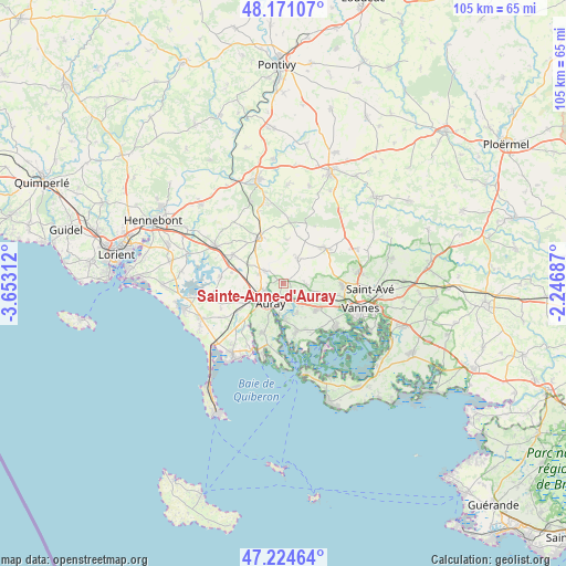
Sainte-Anne-d'Auray GPS coordinates[2]
47° 42' 0" North, 2° 57' 0" West
| Map corner | latitude | longitude |
|---|---|---|
| Upper-left | 48.17107°, | -3.65312° |
| Center: | 47.7°, | -2.95° |
| Lower-right: | 47.22464°, | -2.24687° |
| Map W x H: | 105.2×105.2 km | = 65.4×65.4mi |
| max Lat: | 51.07786° ⇑45.8% North |
| Sainte-Anne-d'Auray: | 47.7° |
| min Lat: | ⇓54.2% South 41.3874° |
| min Long | Sainte-Anne-d'A | max Long |
| -5.08615° | -2.95° | 9.52242° |
| W 2.8%⇐ | ⇒97.2% E |
Elevation
Elevation of Sainte-Anne-d'Auray is 49 m = 161 ft, and this is 144.7 m = 475 ft below average elevation for this country.
| Max E: |
2333 m = 7654 ft | 82.2% |
| Avg. | 193.7 m = 635 ft | |
| Sainte-Anne-d'Auray | 49 m = 161 ft | |
Min E: |
-1 m = -3 ft | 17.8% |
See also: France elevation on elevation.city.
Geographical zone
Sainte-Anne-d'Auray is located in North temperate zone (between Tropic of Cancer and the Arctic Circle). Distance of this North polar circle is 2097.4 km =1303.3 mi to North.| Distance of | km | miles | from Sainte-Anne-d'Auray |
|---|---|---|---|
| North Pole | 4703.3 | 2922.5 | to North |
| Arctic Circle | 2097.4 | 1303.3 | to North |
| Tropic Cancer | 2697.8 | 1676.3 | to South |
| Equator | 5303.7 | 3295.6 | to South |


Nearby cities:
15 places around Sainte-Anne-d'Auray: (largest is in red/bold)
• Auray
4.6 km =2.9 mi,  223°
223°
• Baden
9.5 km =5.9 mi,  166°
166°
• Brandivy
8.1 km =5 mi,  2°
2°
• Brech
4.3 km =2.7 mi,  303°
303°
• Crach
10 km =6.2 mi,  202°
202°
• Grand-Champ
10.1 km =6.3 mi,  50°
50°
• Landaul
10.9 km =6.8 mi, 299°
• Le Bono
6.5 km =4 mi,  179°
179°
• Plescop
10.8 km =6.7 mi,  91°
91°
• Ploemel
10.5 km =6.5 mi,  239°
239°
• Ploeren
8 km =5 mi,  126°
126°
• Plougoumelen
6 km =3.7 mi,  155°
155°
• Plumergat
5.3 km =3.3 mi,  29°
29°
• Pluneret
2.8 km =1.7 mi,  192°
192°
• Pluvigner
9.6 km =6 mi,  332°
332°
Sources, notices
• [Note1] Compared only with cities in France existing in our database
• [Src1] Map data: © OpenStreetMap contributors (CC-BY-SA)
• [Src2] Other city data from geonames.org with taken over terms of usage.
• [Src3] Geographical zone / Annual Mean Temperature by Robert A. Rohde @ Wikipedia
