Pluvigner geodata
Pluvigner (Brittany) is a populated place; located in France in Europe/Paris (GMT+2) time zone. With population of 5,775 people, there are 1706 cities with bigger population in this country. Compared to other cities in France, 55.4% of cities are located further ↓South; 97.4% of cities are located further →East and 65.3% of cities have higher elevation than Pluvigner. Note1
Administrative division(s):
- Level 1: Brittany
- Level 2: Morbihan
- Level 3: Arrondissement de Lorient
- Level 4: Pluvigner


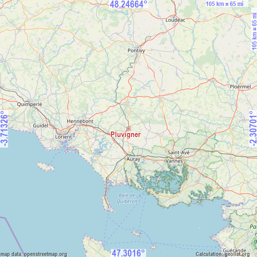
Pluvigner GPS coordinates[2]
47° 46' 34.572" North, 3° 0' 36.468" West
| Map corner | latitude | longitude |
|---|---|---|
| Upper-left | 48.24664°, | -3.71326° |
| Center: | 47.77627°, | -3.01013° |
| Lower-right: | 47.3016°, | -2.30701° |
| Map W x H: | 105.1×105.1 km | = 65.3×65.3mi |
| max Lat: | 51.07786° ⇑44.6% North |
| Pluvigner: | 47.77627° |
| min Lat: | ⇓55.4% South 41.3874° |
| min Long | Pluvigner | max Long |
| -5.08615° | -3.01013° | 9.52242° |
| W 2.6%⇐ | ⇒97.4% E |
Elevation
Elevation of Pluvigner is 89 m = 292 ft, and this is 104.7 m = 344 ft below average elevation for this country.
| Max E: |
2333 m = 7654 ft | 65.3% |
| Avg. | 193.7 m = 635 ft | |
| Pluvigner | 89 m = 292 ft | |
Min E: |
-1 m = -3 ft | 34.7% |
See also: France elevation on elevation.city.
Geographical zone
Pluvigner is located in North temperate zone (between Tropic of Cancer and the Arctic Circle). Distance of this North polar circle is 2089 km =1298 mi to North.| Distance of | km | miles | from Pluvigner |
|---|---|---|---|
| North Pole | 4694.8 | 2917.2 | to North |
| Arctic Circle | 2089 | 1298 | to North |
| Tropic Cancer | 2706.3 | 1681.6 | to South |
| Equator | 5312.2 | 3300.8 | to South |


Nearby cities:
15 places around Pluvigner: (largest is in red/bold)
• Auray
11.9 km =7.4 mi,  173°
173°
• Baud
11 km =6.8 mi,  357°
357°
• Brandivy
4.9 km =3 mi,  94°
94°
• Brech
6.2 km =3.9 mi, 171°
• Camors
7.9 km =4.9 mi,  5°
5°
• Grand-Champ
12.4 km =7.7 mi,  99°
99°
• La Chapelle-Neuve
11.1 km =6.9 mi,  28°
28°
• Landaul
5.9 km =3.7 mi,  237°
237°
• Landévant
8.5 km =5.3 mi,  261°
261°
• Languidic
12.7 km =7.9 mi,  299°
299°
• Locoal-Mendon
10.8 km =6.7 mi,  222°
222°
• Plumelin
13.1 km =8.1 mi,  44°
44°
• Plumergat
8.1 km =5 mi,  118°
118°
• Pluneret
11.9 km =7.4 mi,  160°
160°
• Sainte-Anne-d'Auray
9.6 km =6 mi,  152°
152°
Sources, notices
• [Note1] Compared only with cities in France existing in our database
• [Src1] Map data: © OpenStreetMap contributors (CC-BY-SA)
• [Src2] Other city data from geonames.org with taken over terms of usage.
• [Src3] Geographical zone / Annual Mean Temperature by Robert A. Rohde @ Wikipedia
