Saint-Chamond geodata
Saint-Chamond (Auvergne-Rhône-Alpes) is a populated place; located in France in Europe/Paris (GMT+2) time zone. With population of 38,014 people, there are 200 cities with bigger population in this country. Compared to other cities in France, 74.4% of cities are located further ↑North; 72.2% of cities are located further ←West and 85.7% of cities have lower elevation than Saint-Chamond. Note1
Administrative division(s):
- Level 1: Auvergne-Rhône-Alpes
- Level 2: Département de la Loire
- Level 3: Arrondissement de Saint-Étienne
- Level 4: Saint-Chamond


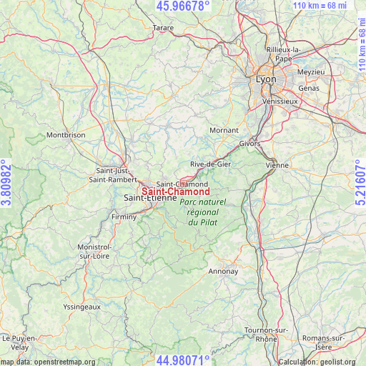
Saint-Chamond GPS coordinates[2]
45° 28' 33.24" North, 4° 30' 46.584" East
| Map corner | latitude | longitude |
|---|---|---|
| Upper-left | 45.96678°, | 3.80982° |
| Center: | 45.4759°, | 4.51294° |
| Lower-right: | 44.98071°, | 5.21607° |
| Map W x H: | 109.6×109.6 km | = 68.1×68.1mi |
| max Lat: | 51.07786° ⇑74.4% North |
| Saint-Chamond: | 45.4759° |
| min Lat: | ⇓25.6% South 41.3874° |
| min Long | Saint-Chamond | max Long |
| -5.08615° | 4.51294° | 9.52242° |
| W 72.2%⇐ | ⇒27.8% E |
Elevation
Elevation of Saint-Chamond is 355 m = 1165 ft, and this is 161.3 m = 529 ft above average elevation for this country.
| Max E: |
2333 m = 7654 ft | 14.3% |
| Saint-Chamond | 355 m 1165 ft | |
| Avg. | 193.7 m = 635 ft | |
Min E: |
-1 m = -3 ft | 85.7% |
See also: France elevation on elevation.city.
Geographical zone
Saint-Chamond is located in North temperate zone (between Tropic of Cancer and the Arctic Circle). Distance of this North polar circle is 2344.7 km =1456.9 mi to North.| Distance of | km | miles | from Saint-Chamond |
|---|---|---|---|
| North Pole | 4950.6 | 3076.2 | to North |
| Arctic Circle | 2344.7 | 1456.9 | to North |
| Tropic Cancer | 2450.5 | 1522.7 | to South |
| Equator | 5056.4 | 3141.9 | to South |


Nearby cities:
15 places around Saint-Chamond: (largest is in red/bold)
• Cellieu
5.3 km =3.3 mi,  26°
26°
• Doizieux
7.7 km =4.8 mi,  134°
134°
• Farnay
5.9 km =3.7 mi,  67°
67°
• La Grand-Croix
4.8 km =3 mi,  49°
49°
• La Talaudière
6.8 km =4.2 mi,  270°
270°
• La Terrasse-sur-Dorlay
6.1 km =3.8 mi,  117°
117°
• La Tour-en-Jarez
9.6 km =6 mi,  275°
275°
• La Valla-en-Gier
6.3 km =3.9 mi,  176°
176°
• Lorette
6.7 km =4.2 mi, 54°
• Saint-Christo-en-Jarez
7.9 km =4.9 mi,  345°
345°
• Saint-Jean-Bonnefonds
5.9 km =3.7 mi,  248°
248°
• Saint-Paul-en-Jarez
4.7 km =2.9 mi,  77°
77°
• Saint-Romain-en-Jarez
9.4 km =5.8 mi,  10°
10°
• Sorbiers
5.8 km =3.6 mi,  286°
286°
• Valfleury
5.5 km =3.4 mi,  342°
342°
Sources, notices
• [Note1] Compared only with cities in France existing in our database
• [Src1] Map data: © OpenStreetMap contributors (CC-BY-SA)
• [Src2] Other city data from geonames.org with taken over terms of usage.
• [Src3] Geographical zone / Annual Mean Temperature by Robert A. Rohde @ Wikipedia
