Saint-Christo-en-Jarez geodata
Saint-Christo-en-Jarez (Auvergne-Rhône-Alpes) is a populated place; located in France in Europe/Paris (GMT+2) time zone. With population of 1,394 people, there are 6632 cities with bigger population in this country. Compared to other cities in France, 73.5% of cities are located further ↑North; 72% of cities are located further ←West and 97.5% of cities have lower elevation than Saint-Christo-en-Jarez. Note1
Administrative division(s):
- Level 1: Auvergne-Rhône-Alpes
- Level 2: Département de la Loire
- Level 3: Arrondissement de Saint-Étienne
- Level 4: Saint-Christo-en-Jarez
Current local time in Saint-Christo-en-Jarez:
02:29 PM, SaturdayDifference from your time zone: hours


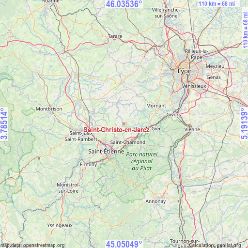
Saint-Christo-en-Jarez GPS coordinates[2]
45° 32' 42.288" North, 4° 29' 17.736" East
| Map corner | latitude | longitude |
|---|---|---|
| Upper-left | 46.03536°, | 3.78514° |
| Center: | 45.54508°, | 4.48826° |
| Lower-right: | 45.05049°, | 5.19139° |
| Map W x H: | 109.5×109.5 km | = 68×68mi |
| max Lat: | 51.07786° ⇑73.5% North |
| Saint-Christo-en-Jarez: | 45.54508° |
| min Lat: | ⇓26.5% South 41.3874° |
| min Long | Saint-Christo-e | max Long |
| -5.08615° | 4.48826° | 9.52242° |
| W 72%⇐ | ⇒28% E |
Elevation
Elevation of Saint-Christo-en-Jarez is 776 m = 2546 ft, and this is 582.3 m = 1910 ft above average elevation for this country.
| Max E: |
2333 m = 7654 ft | 2.5% |
| Saint-Christo-en-Jarez | 776 m 2546 ft | |
| Avg. | 193.7 m = 635 ft | |
Min E: |
-1 m = -3 ft | 97.5% |
See also: France elevation on elevation.city.
Geographical zone
Saint-Christo-en-Jarez is located in North temperate zone (between Tropic of Cancer and the Arctic Circle). Distance of this North polar circle is 2337 km =1452.1 mi to North.| Distance of | km | miles | from Saint-Christo-en-Jarez |
|---|---|---|---|
| North Pole | 4942.9 | 3071.4 | to North |
| Arctic Circle | 2337 | 1452.1 | to North |
| Tropic Cancer | 2458.2 | 1527.5 | to South |
| Equator | 5064.1 | 3146.7 | to South |


Nearby cities:
15 places around Saint-Christo-en-Jarez: (largest is in red/bold)
• Cellieu
5.2 km =3.2 mi,  124°
124°
• Chevrières
8.3 km =5.2 mi,  306°
306°
• Coise
7.7 km =4.8 mi,  351°
351°
• Fontanès
3.7 km =2.3 mi,  274°
274°
• Grammond
4.3 km =2.7 mi,  303°
303°
• La Grand-Croix
7.2 km =4.5 mi,  129°
129°
• Larajasse
7.7 km =4.8 mi,  7°
7°
• Lorette
8.3 km =5.2 mi, 117°
• Marcenod
2.9 km =1.8 mi, 352°
• Saint-Chamond
7.9 km =4.9 mi,  165°
165°
• Saint-Martin-la-Plaine
8.5 km =5.3 mi,  89°
89°
• Saint-Romain-en-Jarez
4 km =2.5 mi,  67°
67°
• Sainte-Catherine
8.7 km =5.4 mi,  46°
46°
• Sorbiers
7 km =4.3 mi,  211°
211°
• Valfleury
2.5 km =1.6 mi, 172°
Sources, notices
• [Note1] Compared only with cities in France existing in our database
• [Src1] Map data: © OpenStreetMap contributors (CC-BY-SA)
• [Src2] Other city data from geonames.org with taken over terms of usage.
• [Src3] Geographical zone / Annual Mean Temperature by Robert A. Rohde @ Wikipedia
