Sorbiers geodata
Sorbiers (Auvergne-Rhône-Alpes) is a populated place; located in France in Europe/Paris (GMT+2) time zone. With population of 7,549 people, there are 1291 cities with bigger population in this country. Compared to other cities in France, 74.2% of cities are located further ↑North; 71.6% of cities are located further ←West and 93.8% of cities have lower elevation than Sorbiers. Note1
Administrative division(s):
- Level 1: Auvergne-Rhône-Alpes
- Level 2: Département de la Loire
- Level 3: Arrondissement de Saint-Étienne
- Level 4: Sorbiers


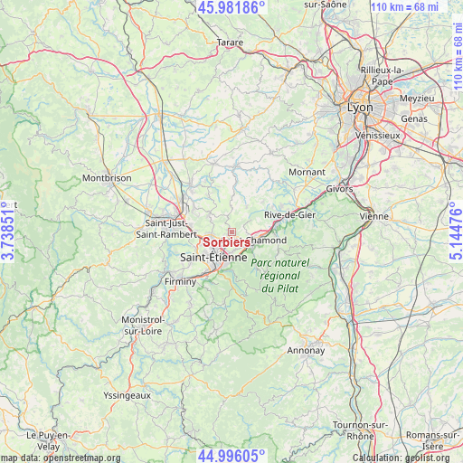
Sorbiers GPS coordinates[2]
45° 29' 27.996" North, 4° 26' 29.868" East
| Map corner | latitude | longitude |
|---|---|---|
| Upper-left | 45.98186°, | 3.73851° |
| Center: | 45.49111°, | 4.44163° |
| Lower-right: | 44.99605°, | 5.14476° |
| Map W x H: | 109.6×109.6 km | = 68.1×68.1mi |
| max Lat: | 51.07786° ⇑74.2% North |
| Sorbiers: | 45.49111° |
| min Lat: | ⇓25.8% South 41.3874° |
| min Long | Sorbiers | max Long |
| -5.08615° | 4.44163° | 9.52242° |
| W 71.6%⇐ | ⇒28.4% E |
Elevation
Elevation of Sorbiers is 536 m = 1759 ft, and this is 342.3 m = 1123 ft above average elevation for this country.
| Max E: |
2333 m = 7654 ft | 6.2% |
| Sorbiers | 536 m 1759 ft | |
| Avg. | 193.7 m = 635 ft | |
Min E: |
-1 m = -3 ft | 93.8% |
See also: France elevation on elevation.city.
Geographical zone
Sorbiers is located in North temperate zone (between Tropic of Cancer and the Arctic Circle). Distance of this North polar circle is 2343 km =1455.9 mi to North.| Distance of | km | miles | from Sorbiers |
|---|---|---|---|
| North Pole | 4948.9 | 3075.1 | to North |
| Arctic Circle | 2343 | 1455.9 | to North |
| Tropic Cancer | 2452.2 | 1523.7 | to South |
| Equator | 5058.1 | 3143 | to South |


Nearby cities:
15 places around Sorbiers: (largest is in red/bold)
• Cellieu
8.5 km =5.3 mi,  68°
68°
• Fontanès
6.3 km =3.9 mi,  359°
359°
• Grammond
8.3 km =5.2 mi,  0°
0°
• La Grand-Croix
9.3 km =5.8 mi,  81°
81°
• La Talaudière
2.1 km =1.3 mi,  215°
215°
• La Tour-en-Jarez
4.1 km =2.5 mi,  257°
257°
• L’Étrat
5.2 km =3.2 mi, 263°
• Saint-Chamond
5.8 km =3.6 mi,  106°
106°
• Saint-Christo-en-Jarez
7 km =4.3 mi,  31°
31°
• Saint-Héand
6.8 km =4.2 mi,  306°
306°
• Saint-Jean-Bonnefonds
3.9 km =2.4 mi,  179°
179°
• Saint-Priest-en-Jarez
5.4 km =3.4 mi,  249°
249°
• Saint-Étienne
7.5 km =4.7 mi,  212°
212°
• Valfleury
5.3 km =3.3 mi,  47°
47°
• Villars
7.2 km =4.5 mi, 248°
Sources, notices
• [Note1] Compared only with cities in France existing in our database
• [Src1] Map data: © OpenStreetMap contributors (CC-BY-SA)
• [Src2] Other city data from geonames.org with taken over terms of usage.
• [Src3] Geographical zone / Annual Mean Temperature by Robert A. Rohde @ Wikipedia
