Saint-Amand-Montrond geodata
Saint-Amand-Montrond (Centre) is a seat of a third-order administrative division; located in France in Europe/Paris (GMT+2) time zone. With population of 11,976 people, there are 803 cities with bigger population in this country. Compared to other cities in France, 58% of cities are located further ↑North; 50.7% of cities are located further ←West and 57.4% of cities have lower elevation than Saint-Amand-Montrond. Note1
Administrative division(s):
- Level 1: Centre
- Level 2: Cher
- Level 3: Arrondissement de Saint-Amand-Montrond
- Level 4: Saint-Amand-Montrond


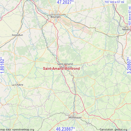
Saint-Amand-Montrond GPS coordinates[2]
46° 43' 22.224" North, 2° 30' 17.784" East
| Map corner | latitude | longitude |
|---|---|---|
| Upper-left | 47.2027°, | 1.80182° |
| Center: | 46.72284°, | 2.50494° |
| Lower-right: | 46.23867°, | 3.20807° |
| Map W x H: | 107.2×107.2 km | = 66.6×66.6mi |
| max Lat: | 51.07786° ⇑58% North |
| Saint-Amand-Montrond: | 46.72284° |
| min Lat: | ⇓42% South 41.3874° |
| min Long | Saint-Amand-Mon | max Long |
| -5.08615° | 2.50494° | 9.52242° |
| W 50.7%⇐ | ⇒49.3% E |
Elevation
Elevation of Saint-Amand-Montrond is 159 m = 522 ft, and this is 34.7 m = 114 ft below average elevation for this country.
| Max E: |
2333 m = 7654 ft | 42.6% |
| Avg. | 193.7 m = 635 ft | |
| Saint-Amand-Montrond | 159 m = 522 ft | |
Min E: |
-1 m = -3 ft | 57.4% |
See also: France elevation on elevation.city.
Geographical zone
Saint-Amand-Montrond is located in North temperate zone (between Tropic of Cancer and the Arctic Circle). Distance of this North polar circle is 2206.1 km =1370.8 mi to North.| Distance of | km | miles | from Saint-Amand-Montrond |
|---|---|---|---|
| North Pole | 4812 | 2990 | to North |
| Arctic Circle | 2206.1 | 1370.8 | to North |
| Tropic Cancer | 2589.2 | 1608.9 | to South |
| Equator | 5195.1 | 3228.1 | to South |


Nearby cities:
15 places around Saint-Amand-Montrond: (largest is in red/bold)
• Ainay-le-Château
14.3 km =8.9 mi,  95°
95°
• Bruère-Allichamps
7.5 km =4.7 mi,  312°
312°
• Charenton-du-Cher
10.7 km =6.6 mi,  85°
85°
• Châteauneuf-sur-Cher
20.7 km =12.9 mi,  316°
316°
• Drevant
3.6 km =2.2 mi,  155°
155°
• Dun-sur-Auron
18.8 km =11.7 mi,  16°
16°
• Le Châtelet
19.2 km =11.9 mi,  242°
242°
• Meaulne
16.2 km =10.1 mi,  148°
148°
• Meillant
6.6 km =4.1 mi,  0°
0°
• Orval
2.6 km =1.6 mi,  277°
277°
• Saint-Bonnet-Tronçais
16 km =9.9 mi,  115°
115°
• Saint-Pierre-les-Étieux
9.1 km =5.7 mi,  81°
81°
• Vallenay
12.3 km =7.6 mi,  303°
303°
• Venesmes
19.5 km =12.1 mi, 311°
• Vesdun
21.2 km =13.2 mi,  195°
195°
In other languages:
- In France: Saint-Amand-Montrond, Saint-Amand-Mont-Rond
- In Russian: Сент-Аман-Монрон
- In Chinese: 圣阿芒蒙特龙
Sources, notices
• [Note1] Compared only with cities in France existing in our database
• [Src1] Map data: © OpenStreetMap contributors (CC-BY-SA)
• [Src2] Other city data from geonames.org with taken over terms of usage.
• [Src3] Geographical zone / Annual Mean Temperature by Robert A. Rohde @ Wikipedia
