Charenton-du-Cher geodata
Charenton-du-Cher (Centre) is a populated place; located in France in Europe/Paris (GMT+2) time zone. With population of 1,101 people, there are 8123 cities with bigger population in this country. Compared to other cities in France, 57.9% of cities are located further ↑North; 52.7% of cities are located further ←West and 62.1% of cities have lower elevation than Charenton-du-Cher. Note1
Administrative division(s):
- Level 1: Centre
- Level 2: Cher
- Level 3: Arrondissement de Saint-Amand-Montrond
- Level 4: Charenton-du-Cher


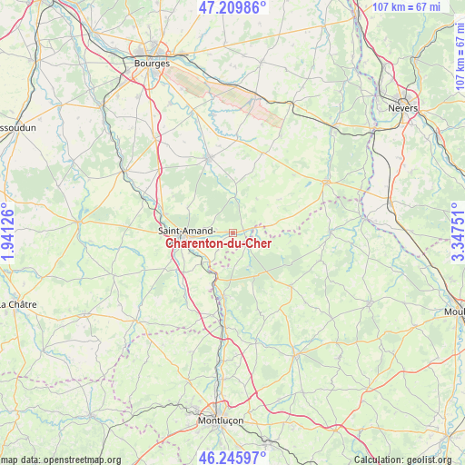
Charenton-du-Cher GPS coordinates[2]
46° 43' 48.252" North, 2° 38' 39.768" East
| Map corner | latitude | longitude |
|---|---|---|
| Upper-left | 47.20986°, | 1.94126° |
| Center: | 46.73007°, | 2.64438° |
| Lower-right: | 46.24597°, | 3.34751° |
| Map W x H: | 107.2×107.2 km | = 66.6×66.6mi |
| max Lat: | 51.07786° ⇑57.9% North |
| Charenton-du-Cher: | 46.73007° |
| min Lat: | ⇓42.1% South 41.3874° |
| min Long | Charenton-du-Ch | max Long |
| -5.08615° | 2.64438° | 9.52242° |
| W 52.7%⇐ | ⇒47.3% E |
Elevation
Elevation of Charenton-du-Cher is 180 m = 591 ft, and this is 13.7 m = 45 ft below average elevation for this country.
| Max E: |
2333 m = 7654 ft | 37.9% |
| Avg. | 193.7 m = 635 ft | |
| Charenton-du-Cher | 180 m = 591 ft | |
Min E: |
-1 m = -3 ft | 62.1% |
See also: France elevation on elevation.city.
Geographical zone
Charenton-du-Cher is located in North temperate zone (between Tropic of Cancer and the Arctic Circle). Distance of this North polar circle is 2205.3 km =1370.3 mi to North.| Distance of | km | miles | from Charenton-du-Cher |
|---|---|---|---|
| North Pole | 4811.2 | 2989.5 | to North |
| Arctic Circle | 2205.3 | 1370.3 | to North |
| Tropic Cancer | 2590 | 1609.4 | to South |
| Equator | 5195.9 | 3228.6 | to South |


Nearby cities:
15 places around Charenton-du-Cher: (largest is in red/bold)
• Ainay-le-Château
4.2 km =2.6 mi,  119°
119°
• Blet
19.5 km =12.1 mi,  20°
20°
• Bruère-Allichamps
16.7 km =10.4 mi,  284°
284°
• Couleuvre
21.1 km =13.1 mi,  107°
107°
• Cérilly
18.3 km =11.4 mi,  132°
132°
• Drevant
10 km =6.2 mi,  245°
245°
• Dun-sur-Auron
18 km =11.2 mi,  342°
342°
• Meaulne
14.8 km =9.2 mi,  188°
188°
• Meillant
12.1 km =7.5 mi,  298°
298°
• Orval
13.2 km =8.2 mi,  267°
267°
• Saint-Amand-Montrond
10.7 km =6.6 mi, 265°
• Saint-Bonnet-Tronçais
8.6 km =5.3 mi,  154°
154°
• Saint-Pierre-les-Étieux
1.7 km =1.1 mi,  286°
286°
• Vallenay
21.7 km =13.5 mi, 286°
• Vallon-en-Sully
21.7 km =13.5 mi, 187°
Sources, notices
• [Note1] Compared only with cities in France existing in our database
• [Src1] Map data: © OpenStreetMap contributors (CC-BY-SA)
• [Src2] Other city data from geonames.org with taken over terms of usage.
• [Src3] Geographical zone / Annual Mean Temperature by Robert A. Rohde @ Wikipedia
