Dun-sur-Auron geodata
Dun-sur-Auron (Centre) is a populated place; located in France in Europe/Paris (GMT+2) time zone. With population of 3,829 people, there are 2570 cities with bigger population in this country. Compared to other cities in France, 56.3% of cities are located further ↑North; 51.7% of cities are located further ←West and 61% of cities have lower elevation than Dun-sur-Auron. Note1
Administrative division(s):
- Level 1: Centre
- Level 2: Cher
- Level 3: Arrondissement de Saint-Amand-Montrond
- Level 4: Dun-sur-Auron


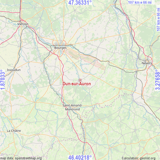
Dun-sur-Auron GPS coordinates[2]
46° 53' 5.64" North, 2° 34' 24.42" East
| Map corner | latitude | longitude |
|---|---|---|
| Upper-left | 47.36331°, | 1.87033° |
| Center: | 46.8849°, | 2.57345° |
| Lower-right: | 46.40218°, | 3.27658° |
| Map W x H: | 106.9×106.9 km | = 66.4×66.4mi |
| max Lat: | 51.07786° ⇑56.3% North |
| Dun-sur-Auron: | 46.8849° |
| min Lat: | ⇓43.7% South 41.3874° |
| min Long | Dun-sur-Auron | max Long |
| -5.08615° | 2.57345° | 9.52242° |
| W 51.7%⇐ | ⇒48.3% E |
Elevation
Elevation of Dun-sur-Auron is 175 m = 574 ft, and this is 18.7 m = 61 ft below average elevation for this country.
| Max E: |
2333 m = 7654 ft | 39% |
| Avg. | 193.7 m = 635 ft | |
| Dun-sur-Auron | 175 m = 574 ft | |
Min E: |
-1 m = -3 ft | 61% |
See also: France elevation on elevation.city.
Geographical zone
Dun-sur-Auron is located in North temperate zone (between Tropic of Cancer and the Arctic Circle). Distance of this North polar circle is 2188.1 km =1359.6 mi to North.| Distance of | km | miles | from Dun-sur-Auron |
|---|---|---|---|
| North Pole | 4793.9 | 2978.8 | to North |
| Arctic Circle | 2188.1 | 1359.6 | to North |
| Tropic Cancer | 2607.2 | 1620 | to South |
| Equator | 5213.1 | 3239.3 | to South |


Nearby cities:
15 places around Dun-sur-Auron: (largest is in red/bold)
• Avord
17.8 km =11.1 mi,  19°
19°
• Bengy-sur-Craon
18.4 km =11.4 mi,  45°
45°
• Blet
12.1 km =7.5 mi,  84°
84°
• Bruère-Allichamps
16.8 km =10.4 mi,  219°
219°
• Charenton-du-Cher
18 km =11.2 mi,  162°
162°
• Levet
13.4 km =8.3 mi,  289°
289°
• Meillant
12.5 km =7.8 mi,  204°
204°
• Ourouer-les-Bourdelins
18.8 km =11.7 mi, 79°
• Plaimpied-Givaudins
15.5 km =9.6 mi,  324°
324°
• Saint-Amand-Montrond
18.8 km =11.7 mi, 196°
• Saint-Germain-des-Bois
10.2 km =6.3 mi, 287°
• Saint-Just
13.1 km =8.1 mi,  337°
337°
• Saint-Pierre-les-Étieux
17.2 km =10.7 mi,  167°
167°
• Savigny-en-Septaine
17.7 km =11 mi,  356°
356°
• Soye-en-Septaine
17.1 km =10.6 mi, 337°
Sources, notices
• [Note1] Compared only with cities in France existing in our database
• [Src1] Map data: © OpenStreetMap contributors (CC-BY-SA)
• [Src2] Other city data from geonames.org with taken over terms of usage.
• [Src3] Geographical zone / Annual Mean Temperature by Robert A. Rohde @ Wikipedia
