Sablonnières geodata
Sablonnières (Île-de-France) is a populated place; located in France in Europe/Paris (GMT+2) time zone. With population of 692 people, there are 11913 cities with bigger population in this country. Compared to other cities in France, 77.1% of cities are located further ↓South; 62% of cities are located further ←West and 67% of cities have higher elevation than Sablonnières. Note1
Administrative division(s):
- Level 1: Île-de-France
- Level 2: Seine-et-Marne
- Level 3: Arrondissement de Provins
- Level 4: Sablonnières


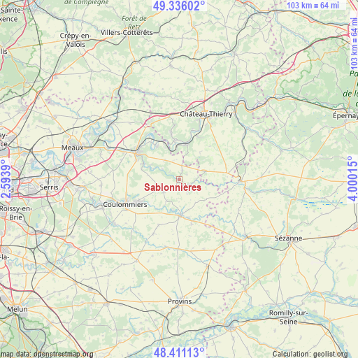
Sablonnières GPS coordinates[2]
48° 52' 32.556" North, 3° 17' 49.272" East
| Map corner | latitude | longitude |
|---|---|---|
| Upper-left | 49.33602°, | 2.5939° |
| Center: | 48.87571°, | 3.29702° |
| Lower-right: | 48.41113°, | 4.00015° |
| Map W x H: | 102.8×102.8 km | = 63.9×63.9mi |
| max Lat: | 51.07786° ⇑22.9% North |
| Sablonnières: | 48.87571° |
| min Lat: | ⇓77.1% South 41.3874° |
| min Long | Sablonnières | max Long |
| -5.08615° | 3.29702° | 9.52242° |
| W 62%⇐ | ⇒38% E |
Elevation
Elevation of Sablonnières is 85 m = 279 ft, and this is 108.7 m = 357 ft below average elevation for this country.
| Max E: |
2333 m = 7654 ft | 67% |
| Avg. | 193.7 m = 635 ft | |
| Sablonnières | 85 m = 279 ft | |
Min E: |
-1 m = -3 ft | 33% |
See also: France elevation on elevation.city.
Geographical zone
Sablonnières is located in North temperate zone (between Tropic of Cancer and the Arctic Circle). Distance of this North polar circle is 1966.7 km =1222.1 mi to North.| Distance of | km | miles | from Sablonnières |
|---|---|---|---|
| North Pole | 4572.6 | 2841.3 | to North |
| Arctic Circle | 1966.7 | 1222.1 | to North |
| Tropic Cancer | 2828.6 | 1757.6 | to South |
| Equator | 5434.5 | 3376.8 | to South |


Nearby cities:
15 places around Sablonnières: (largest is in red/bold)
• Bellot
2.6 km =1.6 mi,  143°
143°
• Doue
9.9 km =6.2 mi,  263°
263°
• Jouy-sur-Morin
9.2 km =5.7 mi,  191°
191°
• La Ferté-Gaucher
10.3 km =6.4 mi,  176°
176°
• Nogent-l’Artaud
10.2 km =6.3 mi,  10°
10°
• Orly-sur-Morin
5.8 km =3.6 mi,  302°
302°
• Pavant
8.7 km =5.4 mi,  354°
354°
• Rebais
5.7 km =3.5 mi,  236°
236°
• Saint-Cyr-sur-Morin
9.2 km =5.7 mi,  291°
291°
• Saint-Denis-lès-Rebais
7.8 km =4.8 mi,  234°
234°
• Saint-Ouen-sur-Morin
7.6 km =4.7 mi, 292°
• Saint-Rémy-la-Vanne
10.5 km =6.5 mi,  206°
206°
• Verdelot
5 km =3.1 mi,  90°
90°
• Viels-Maisons
7.6 km =4.7 mi,  72°
72°
• Villeneuve-sur-Bellot
3.6 km =2.2 mi,  115°
115°
Sources, notices
• [Note1] Compared only with cities in France existing in our database
• [Src1] Map data: © OpenStreetMap contributors (CC-BY-SA)
• [Src2] Other city data from geonames.org with taken over terms of usage.
• [Src3] Geographical zone / Annual Mean Temperature by Robert A. Rohde @ Wikipedia
