Ruffey-sur-Seille geodata
Ruffey-sur-Seille (Bourgogne-Franche-Comté) is a populated place; located in France in Europe/Paris (GMT+2) time zone. With population of 760 people, there are 11054 cities with bigger population in this country. Compared to other cities in France, 57.8% of cities are located further ↑North; 82.8% of cities are located further ←West and 68.1% of cities have lower elevation than Ruffey-sur-Seille. Note1
Administrative division(s):
- Level 1: Bourgogne-Franche-Comté
- Level 2: Jura
- Level 3: Arrondissement de Lons-le-Saunier
- Level 4: Ruffey-sur-Seille


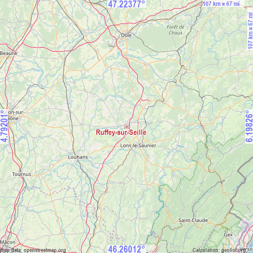
Ruffey-sur-Seille GPS coordinates[2]
46° 44' 38.76" North, 5° 29' 42.504" East
| Map corner | latitude | longitude |
|---|---|---|
| Upper-left | 47.22377°, | 4.79201° |
| Center: | 46.7441°, | 5.49514° |
| Lower-right: | 46.26012°, | 6.19826° |
| Map W x H: | 107.1×107.1 km | = 66.5×66.5mi |
| max Lat: | 51.07786° ⇑57.8% North |
| Ruffey-sur-Seille: | 46.7441° |
| min Lat: | ⇓42.2% South 41.3874° |
| min Long | Ruffey-sur-Seil | max Long |
| -5.08615° | 5.49514° | 9.52242° |
| W 82.8%⇐ | ⇒17.2% E |
Elevation
Elevation of Ruffey-sur-Seille is 210 m = 689 ft, and this is 16.3 m = 53 ft above average elevation for this country.
| Max E: |
2333 m = 7654 ft | 31.9% |
| Ruffey-sur-Seille | 210 m 689 ft | |
| Avg. | 193.7 m = 635 ft | |
Min E: |
-1 m = -3 ft | 68.1% |
See also: France elevation on elevation.city.
Geographical zone
Ruffey-sur-Seille is located in North temperate zone (between Tropic of Cancer and the Arctic Circle). Distance of this North polar circle is 2203.7 km =1369.3 mi to North.| Distance of | km | miles | from Ruffey-sur-Seille |
|---|---|---|---|
| North Pole | 4809.6 | 2988.5 | to North |
| Arctic Circle | 2203.7 | 1369.3 | to North |
| Tropic Cancer | 2591.5 | 1610.3 | to South |
| Equator | 5197.5 | 3229.6 | to South |


Nearby cities:
15 places around Ruffey-sur-Seille: (largest is in red/bold)
• Arlay
3.3 km =2.1 mi,  54°
54°
• Bletterans
3.1 km =1.9 mi,  275°
275°
• Commenailles
7.3 km =4.5 mi,  333°
333°
• Courlans
7.7 km =4.8 mi,  179°
179°
• Courlaoux
8.7 km =5.4 mi,  197°
197°
• Domblans
8 km =5 mi,  74°
74°
• Larnaud
4.8 km =3 mi,  220°
220°
• Lons-le-Saunier
8.9 km =5.5 mi,  148°
148°
• Messia-sur-Sorne
9.2 km =5.7 mi,  172°
172°
• Montmorot
7.9 km =4.9 mi,  164°
164°
• Plainoiseau
4.9 km =3 mi,  104°
104°
• Saint-Germain-lès-Arlay
5.2 km =3.2 mi, 70°
• Sellières
10.7 km =6.6 mi,  29°
29°
• Villevieux
2.5 km =1.6 mi,  251°
251°
• Voiteur
8.9 km =5.5 mi,  82°
82°
Sources, notices
• [Note1] Compared only with cities in France existing in our database
• [Src1] Map data: © OpenStreetMap contributors (CC-BY-SA)
• [Src2] Other city data from geonames.org with taken over terms of usage.
• [Src3] Geographical zone / Annual Mean Temperature by Robert A. Rohde @ Wikipedia
