Rots geodata
Rots (Normandy) is a populated place; located in France in Europe/Paris (GMT+2) time zone. With population of 1,417 people, there are 6530 cities with bigger population in this country. Compared to other cities in France, 84.5% of cities are located further ↓South; 83% of cities are located further →East and 81.8% of cities have higher elevation than Rots. Note1
Administrative division(s):
- Level 1: Normandy
- Level 2: Calvados
- Level 3: Arrondissement de Caen
- Level 4: Rots


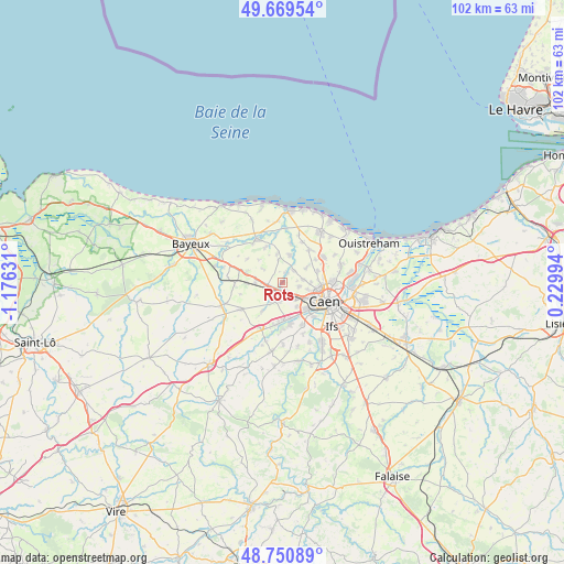
Rots GPS coordinates[2]
49° 12' 44.46" North, 0° 28' 23.484" West
| Map corner | latitude | longitude |
|---|---|---|
| Upper-left | 49.66954°, | -1.17631° |
| Center: | 49.21235°, | -0.47319° |
| Lower-right: | 48.75089°, | 0.22994° |
| Map W x H: | 102.1×102.1 km | = 63.4×63.4mi |
| max Lat: | 51.07786° ⇑15.5% North |
| Rots: | 49.21235° |
| min Lat: | ⇓84.5% South 41.3874° |
| min Long | Rots | max Long |
| -5.08615° | -0.47319° | 9.52242° |
| W 17%⇐ | ⇒83% E |
Elevation
Elevation of Rots is 50 m = 164 ft, and this is 143.7 m = 471 ft below average elevation for this country.
| Max E: |
2333 m = 7654 ft | 81.8% |
| Avg. | 193.7 m = 635 ft | |
| Rots | 50 m = 164 ft | |
Min E: |
-1 m = -3 ft | 18.2% |
See also: France elevation on elevation.city.
Geographical zone
Rots is located in North temperate zone (between Tropic of Cancer and the Arctic Circle). Distance of this North polar circle is 1929.3 km =1198.8 mi to North.| Distance of | km | miles | from Rots |
|---|---|---|---|
| North Pole | 4535.2 | 2818 | to North |
| Arctic Circle | 1929.3 | 1198.8 | to North |
| Tropic Cancer | 2866 | 1780.8 | to South |
| Equator | 5471.9 | 3400.1 | to South |


Nearby cities:
15 places around Rots: (largest is in red/bold)
• Authie
3.1 km =1.9 mi,  102°
102°
• Bretteville-l’Orgueilleuse
3 km =1.9 mi,  269°
269°
• Bretteville-sur-Odon
6.6 km =4.1 mi,  141°
141°
• Cairon
3.5 km =2.2 mi,  28°
28°
• Carpiquet
3.6 km =2.2 mi,  147°
147°
• Cheux
6.4 km =4 mi,  216°
216°
• Le Fresne-Camilly
5.4 km =3.4 mi,  348°
348°
• Rosel
2.1 km =1.3 mi, 30°
• Saint-Contest
5.2 km =3.2 mi,  87°
87°
• Saint-Germain-la-Blanche-Herbe
6 km =3.7 mi,  122°
122°
• Saint-Manvieu
4.1 km =2.5 mi,  210°
210°
• Saint-Manvieu-Norrey
4 km =2.5 mi, 209°
• Thaon
5.2 km =3.2 mi,  13°
13°
• Verson
6.6 km =4.1 mi,  169°
169°
• Villons-les-Buissons
5.6 km =3.5 mi,  55°
55°
Sources, notices
• [Note1] Compared only with cities in France existing in our database
• [Src1] Map data: © OpenStreetMap contributors (CC-BY-SA)
• [Src2] Other city data from geonames.org with taken over terms of usage.
• [Src3] Geographical zone / Annual Mean Temperature by Robert A. Rohde @ Wikipedia
