Saint-Germain-la-Blanche-Herbe geodata
Saint-Germain-la-Blanche-Herbe (Normandy) is a populated place; located in France in Europe/Paris (GMT+2) time zone. With population of 2,516 people, there are 3876 cities with bigger population in this country. Compared to other cities in France, 84% of cities are located further ↓South; 82.2% of cities are located further →East and 85.9% of cities have higher elevation than Saint-Germain-la-Blanche-Herbe. Note1
Administrative division(s):
- Level 1: Normandy
- Level 2: Calvados
- Level 3: Arrondissement de Caen
- Level 4: Saint-Germain-la-Blanche-Herbe
Current local time in Saint-Germain-la-Blanche-Herbe:
09:30 AM, WednesdayDifference from your time zone: hours


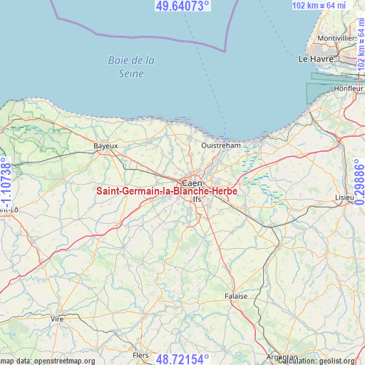
Saint-Germain-la-Blanche-Herbe GPS coordinates[2]
49° 10' 59.772" North, 0° 24' 15.336" West
| Map corner | latitude | longitude |
|---|---|---|
| Upper-left | 49.64073°, | -1.10738° |
| Center: | 49.18327°, | -0.40426° |
| Lower-right: | 48.72154°, | 0.29886° |
| Map W x H: | 102.2×102.2 km | = 63.5×63.5mi |
| max Lat: | 51.07786° ⇑16% North |
| Saint-Germain-la-Blanche-Herbe: | 49.18327° |
| min Lat: | ⇓84% South 41.3874° |
| min Long | Saint-Germain-l | max Long |
| -5.08615° | -0.40426° | 9.52242° |
| W 17.8%⇐ | ⇒82.2% E |
Elevation
Elevation of Saint-Germain-la-Blanche-Herbe is 40 m = 131 ft, and this is 153.7 m = 504 ft below average elevation for this country.
| Max E: |
2333 m = 7654 ft | 85.9% |
| Avg. | 193.7 m = 635 ft | |
| Saint-Germain-la-Blanche-Herbe | 40 m = 131 ft | |
Min E: |
-1 m = -3 ft | 14.1% |
See also: France elevation on elevation.city.
Geographical zone
Saint-Germain-la-Blanche-Herbe is located in North temperate zone (between Tropic of Cancer and the Arctic Circle). Distance of this North polar circle is 1932.5 km =1200.8 mi to North.| Distance of | km | miles | from Saint-Germain-la-Blanche-Herbe |
|---|---|---|---|
| North Pole | 4538.4 | 2820 | to North |
| Arctic Circle | 1932.5 | 1200.8 | to North |
| Tropic Cancer | 2862.7 | 1778.8 | to South |
| Equator | 5468.7 | 3398.1 | to South |


Nearby cities:
15 places around Saint-Germain-la-Blanche-Herbe: (largest is in red/bold)
• Authie
3.2 km =2 mi,  321°
321°
• Bretteville-sur-Odon
2.1 km =1.3 mi,  205°
205°
• Caen
3.3 km =2.1 mi,  85°
85°
• Cambes-en-Plaine
5.5 km =3.4 mi,  14°
14°
• Carpiquet
3.1 km =1.9 mi,  274°
274°
• Cormelles-le-Royal
6.3 km =3.9 mi,  121°
121°
• Fleury-sur-Orne
4.4 km =2.7 mi,  151°
151°
• Fontaine-Étoupefour
5.6 km =3.5 mi,  221°
221°
• Louvigny
3 km =1.9 mi,  165°
165°
• Mondeville
6 km =3.7 mi,  98°
98°
• Rots
6 km =3.7 mi,  302°
302°
• Saint-Contest
3.4 km =2.1 mi,  2°
2°
• Verson
5 km =3.1 mi,  229°
229°
• Épron
4.9 km =3 mi,  29°
29°
• Éterville
4.6 km =2.9 mi,  199°
199°
Sources, notices
• [Note1] Compared only with cities in France existing in our database
• [Src1] Map data: © OpenStreetMap contributors (CC-BY-SA)
• [Src2] Other city data from geonames.org with taken over terms of usage.
• [Src3] Geographical zone / Annual Mean Temperature by Robert A. Rohde @ Wikipedia
