Verson geodata
Verson (Normandy) is a populated place; located in France in Europe/Paris (GMT+2) time zone. With population of 3,763 people, there are 2608 cities with bigger population in this country. Compared to other cities in France, 83.4% of cities are located further ↓South; 82.8% of cities are located further →East and 83.1% of cities have higher elevation than Verson. Note1
Administrative division(s):
- Level 1: Normandy
- Level 2: Calvados
- Level 3: Arrondissement de Caen
- Level 4: Verson


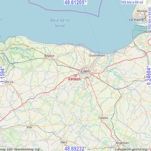
Verson GPS coordinates[2]
49° 9' 15.552" North, 0° 27' 22.608" West
| Map corner | latitude | longitude |
|---|---|---|
| Upper-left | 49.61205°, | -1.1594° |
| Center: | 49.15432°, | -0.45628° |
| Lower-right: | 48.69232°, | 0.24684° |
| Map W x H: | 102.3×102.3 km | = 63.6×63.6mi |
| max Lat: | 51.07786° ⇑16.6% North |
| Verson: | 49.15432° |
| min Lat: | ⇓83.4% South 41.3874° |
| min Long | Verson | max Long |
| -5.08615° | -0.45628° | 9.52242° |
| W 17.2%⇐ | ⇒82.8% E |
Elevation
Elevation of Verson is 47 m = 154 ft, and this is 146.7 m = 481 ft below average elevation for this country.
| Max E: |
2333 m = 7654 ft | 83.1% |
| Avg. | 193.7 m = 635 ft | |
| Verson | 47 m = 154 ft | |
Min E: |
-1 m = -3 ft | 16.9% |
See also: France elevation on elevation.city.
Geographical zone
Verson is located in North temperate zone (between Tropic of Cancer and the Arctic Circle). Distance of this North polar circle is 1935.7 km =1202.8 mi to North.| Distance of | km | miles | from Verson |
|---|---|---|---|
| North Pole | 4541.6 | 2822 | to North |
| Arctic Circle | 1935.7 | 1202.8 | to North |
| Tropic Cancer | 2859.5 | 1776.8 | to South |
| Equator | 5465.4 | 3396 | to South |


Nearby cities:
15 places around Verson: (largest is in red/bold)
• Baron-sur-Odon
2.9 km =1.8 mi,  212°
212°
• Bretteville-sur-Odon
3.2 km =2 mi,  65°
65°
• Carpiquet
3.5 km =2.2 mi,  12°
12°
• Cheux
5.2 km =3.2 mi,  284°
284°
• Esquay-Notre-Dame
4.9 km =3 mi,  193°
193°
• Fontaine-Étoupefour
0.9 km =0.6 mi,  175°
175°
• Louvigny
4.6 km =2.9 mi,  86°
86°
• Maltot
3.8 km =2.4 mi,  140°
140°
• Mouen
2.2 km =1.4 mi,  247°
247°
• Saint-Germain-la-Blanche-Herbe
5 km =3.1 mi,  49°
49°
• Saint-Manvieu
4.4 km =2.7 mi,  311°
311°
• Saint-Manvieu-Norrey
4.4 km =2.7 mi, 313°
• Tourville-sur-Odon
3.6 km =2.2 mi, 246°
• Vieux
5.5 km =3.4 mi,  162°
162°
• Éterville
2.5 km =1.6 mi,  116°
116°
Sources, notices
• [Note1] Compared only with cities in France existing in our database
• [Src1] Map data: © OpenStreetMap contributors (CC-BY-SA)
• [Src2] Other city data from geonames.org with taken over terms of usage.
• [Src3] Geographical zone / Annual Mean Temperature by Robert A. Rohde @ Wikipedia
