Roches-sur-Marne geodata
Roches-sur-Marne (Grand Est) is a populated place; located in France in Europe/Paris (GMT+2) time zone. With population of 624 people, there are 12917 cities with bigger population in this country. Compared to other cities in France, 71% of cities are located further ↓South; 78.1% of cities are located further ←West and 55.9% of cities have lower elevation than Roches-sur-Marne. Note1
Administrative division(s):
- Level 1: Grand Est
- Level 2: Haute-Marne
- Level 3: Arrondissement de Saint-Dizier
- Level 4: Roches-sur-Marne


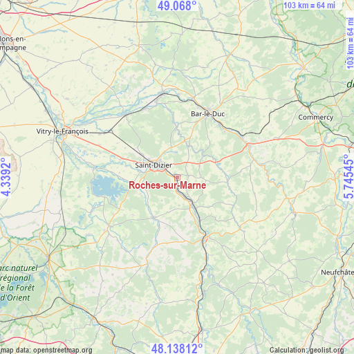
Roches-sur-Marne GPS coordinates[2]
48° 36' 18.72" North, 5° 2' 32.388" East
| Map corner | latitude | longitude |
|---|---|---|
| Upper-left | 49.068°, | 4.3392° |
| Center: | 48.6052°, | 5.04233° |
| Lower-right: | 48.13812°, | 5.74545° |
| Map W x H: | 103.4×103.4 km | = 64.2×64.2mi |
| max Lat: | 51.07786° ⇑29% North |
| Roches-sur-Marne: | 48.6052° |
| min Lat: | ⇓71% South 41.3874° |
| min Long | Roches-sur-Marn | max Long |
| -5.08615° | 5.04233° | 9.52242° |
| W 78.1%⇐ | ⇒21.9% E |
Elevation
Elevation of Roches-sur-Marne is 153 m = 502 ft, and this is 40.7 m = 134 ft below average elevation for this country.
| Max E: |
2333 m = 7654 ft | 44.1% |
| Avg. | 193.7 m = 635 ft | |
| Roches-sur-Marne | 153 m = 502 ft | |
Min E: |
-1 m = -3 ft | 55.9% |
See also: France elevation on elevation.city.
Geographical zone
Roches-sur-Marne is located in North temperate zone (between Tropic of Cancer and the Arctic Circle). Distance of this North polar circle is 1996.8 km =1240.8 mi to North.| Distance of | km | miles | from Roches-sur-Marne |
|---|---|---|---|
| North Pole | 4602.7 | 2860 | to North |
| Arctic Circle | 1996.8 | 1240.8 | to North |
| Tropic Cancer | 2798.5 | 1738.9 | to South |
| Equator | 5404.4 | 3358.1 | to South |


Nearby cities:
15 places around Roches-sur-Marne: (largest is in red/bold)
• Ancerville
3.7 km =2.3 mi,  335°
335°
• Bayard-sur-Marne
6.2 km =3.9 mi,  155°
155°
• Bettancourt-la-Ferrée
7.2 km =4.5 mi,  312°
312°
• Bienville
3.3 km =2.1 mi,  175°
175°
• Chamouilley
0.3 km =0.2 mi,  58°
58°
• Chancenay
8.3 km =5.2 mi,  330°
330°
• Chevillon
10.7 km =6.6 mi,  142°
142°
• Eurville-Bienville
2.5 km =1.6 mi,  195°
195°
• Haironville
9.6 km =6 mi,  19°
19°
• Humbécourt
10.6 km =6.6 mi,  256°
256°
• Moëslains
10.9 km =6.8 mi,  278°
278°
• Rachecourt-sur-Marne
10.1 km =6.3 mi,  153°
153°
• Saint-Dizier
7.8 km =4.8 mi,  297°
297°
• Sommelonne
7.4 km =4.6 mi,  356°
356°
• Valcourt
10 km =6.2 mi, 277°
Sources, notices
• [Note1] Compared only with cities in France existing in our database
• [Src1] Map data: © OpenStreetMap contributors (CC-BY-SA)
• [Src2] Other city data from geonames.org with taken over terms of usage.
• [Src3] Geographical zone / Annual Mean Temperature by Robert A. Rohde @ Wikipedia
