Saint-Dizier geodata
Saint-Dizier (Grand Est) is a seat of a third-order administrative division; located in France in Europe/Paris (GMT+2) time zone. With population of 31,918 people, there are 248 cities with bigger population in this country. Compared to other cities in France, 71.8% of cities are located further ↓South; 77.1% of cities are located further ←West and 52.8% of cities have lower elevation than Saint-Dizier. Note1
Administrative division(s):
- Level 1: Grand Est
- Level 2: Haute-Marne
- Level 3: Arrondissement de Saint-Dizier
- Level 4: Saint-Dizier


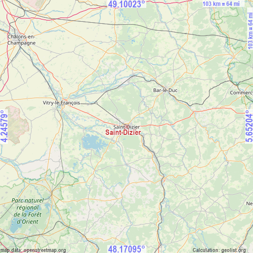
Saint-Dizier GPS coordinates[2]
48° 38' 15.828" North, 4° 56' 56.112" East
| Map corner | latitude | longitude |
|---|---|---|
| Upper-left | 49.10023°, | 4.24579° |
| Center: | 48.63773°, | 4.94892° |
| Lower-right: | 48.17095°, | 5.65204° |
| Map W x H: | 103.3×103.3 km | = 64.2×64.2mi |
| max Lat: | 51.07786° ⇑28.2% North |
| Saint-Dizier: | 48.63773° |
| min Lat: | ⇓71.8% South 41.3874° |
| min Long | Saint-Dizier | max Long |
| -5.08615° | 4.94892° | 9.52242° |
| W 77.1%⇐ | ⇒22.9% E |
Elevation
Elevation of Saint-Dizier is 142 m = 466 ft, and this is 51.7 m = 170 ft below average elevation for this country.
| Max E: |
2333 m = 7654 ft | 47.2% |
| Avg. | 193.7 m = 635 ft | |
| Saint-Dizier | 142 m = 466 ft | |
Min E: |
-1 m = -3 ft | 52.8% |
See also: France elevation on elevation.city.
Geographical zone
Saint-Dizier is located in North temperate zone (between Tropic of Cancer and the Arctic Circle). Distance of this North polar circle is 1993.2 km =1238.5 mi to North.| Distance of | km | miles | from Saint-Dizier |
|---|---|---|---|
| North Pole | 4599.1 | 2857.7 | to North |
| Arctic Circle | 1993.2 | 1238.5 | to North |
| Tropic Cancer | 2802.1 | 1741.1 | to South |
| Equator | 5408 | 3360.4 | to South |


Nearby cities:
15 places around Saint-Dizier: (largest is in red/bold)
• Ancerville
5.3 km =3.3 mi,  92°
92°
• Bettancourt-la-Ferrée
2 km =1.2 mi,  50°
50°
• Bienville
9.9 km =6.2 mi,  134°
134°
• Chamouilley
7.9 km =4.9 mi,  116°
116°
• Chancenay
4.6 km =2.9 mi,  38°
38°
• Eurville-Bienville
8.7 km =5.4 mi, 134°
• Humbécourt
7 km =4.3 mi,  209°
209°
• Lisle-en-Rigault
11.4 km =7.1 mi, 39°
• Louvemont
9.9 km =6.2 mi,  196°
196°
• Moëslains
4.4 km =2.7 mi,  243°
243°
• Perthes
9.4 km =5.8 mi,  282°
282°
• Roches-sur-Marne
7.8 km =4.8 mi, 117°
• Sommelonne
7.4 km =4.6 mi,  59°
59°
• Valcourt
3.8 km =2.4 mi,  232°
232°
• Villiers-en-Lieu
5 km =3.1 mi,  311°
311°
Sources, notices
• [Note1] Compared only with cities in France existing in our database
• [Src1] Map data: © OpenStreetMap contributors (CC-BY-SA)
• [Src2] Other city data from geonames.org with taken over terms of usage.
• [Src3] Geographical zone / Annual Mean Temperature by Robert A. Rohde @ Wikipedia
