Rhinau geodata
Rhinau (Grand Est) is a populated place; located in France in Europe/Paris (GMT+2) time zone. With population of 2,485 people, there are 3909 cities with bigger population in this country. Compared to other cities in France, 65% of cities are located further ↓South; 99% of cities are located further ←West and 56.8% of cities have lower elevation than Rhinau. Note1
Administrative division(s):
- Level 1: Grand Est
- Level 2: Bas-Rhin
- Level 3: Arrondissement de Sélestat-Erstein
- Level 4: Rhinau


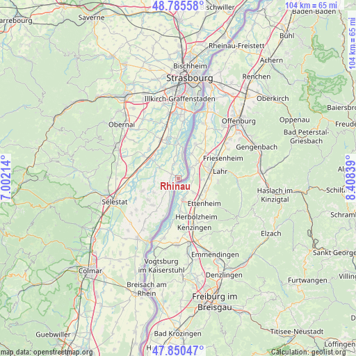
Rhinau GPS coordinates[2]
48° 19' 12.612" North, 7° 42' 18.972" East
| Map corner | latitude | longitude |
|---|---|---|
| Upper-left | 48.78558°, | 7.00214° |
| Center: | 48.32017°, | 7.70527° |
| Lower-right: | 47.85047°, | 8.40839° |
| Map W x H: | 104×104 km | = 64.6×64.6mi |
| max Lat: | 51.07786° ⇑35% North |
| Rhinau: | 48.32017° |
| min Lat: | ⇓65% South 41.3874° |
| min Long | Rhinau | max Long |
| -5.08615° | 7.70527° | 9.52242° |
| W 99%⇐ | ⇒1% E |
Elevation
Elevation of Rhinau is 157 m = 515 ft, and this is 36.7 m = 120 ft below average elevation for this country.
| Max E: |
2333 m = 7654 ft | 43.2% |
| Avg. | 193.7 m = 635 ft | |
| Rhinau | 157 m = 515 ft | |
Min E: |
-1 m = -3 ft | 56.8% |
See also: France elevation on elevation.city.
Geographical zone
Rhinau is located in North temperate zone (between Tropic of Cancer and the Arctic Circle). Distance of this North polar circle is 2028.5 km =1260.5 mi to North.| Distance of | km | miles | from Rhinau |
|---|---|---|---|
| North Pole | 4634.4 | 2879.7 | to North |
| Arctic Circle | 2028.5 | 1260.5 | to North |
| Tropic Cancer | 2766.8 | 1719.2 | to South |
| Equator | 5372.7 | 3338.4 | to South |


Nearby cities:
15 places around Rhinau: (largest is in red/bold)
• Benfeld
10 km =6.2 mi,  304°
304°
• Bindernheim
8.3 km =5.2 mi,  240°
240°
• Boofzheim
2.2 km =1.4 mi,  305°
305°
• Diebolsheim
4.5 km =2.8 mi,  222°
222°
• Friesenheim
2.8 km =1.7 mi, 244°
• Gerstheim
6.9 km =4.3 mi,  359°
359°
• Herbsheim
6.4 km =4 mi, 300°
• Huttenheim
10.3 km =6.4 mi,  294°
294°
• Matzenheim
10.3 km =6.4 mi,  323°
323°
• Obenheim
4.5 km =2.8 mi,  347°
347°
• Osthouse
10.2 km =6.3 mi,  333°
333°
• Rossfeld
6.9 km =4.3 mi, 287°
• Sand
9.8 km =6.1 mi, 315°
• Sundhouse
10.7 km =6.6 mi, 224°
• Wittisheim
10.7 km =6.6 mi,  234°
234°
Sources, notices
• [Note1] Compared only with cities in France existing in our database
• [Src1] Map data: © OpenStreetMap contributors (CC-BY-SA)
• [Src2] Other city data from geonames.org with taken over terms of usage.
• [Src3] Geographical zone / Annual Mean Temperature by Robert A. Rohde @ Wikipedia
