Benfeld geodata
Benfeld (Grand Est) is a populated place; located in France in Europe/Paris (GMT+2) time zone. With population of 5,199 people, there are 1896 cities with bigger population in this country. Compared to other cities in France, 65.9% of cities are located further ↓South; 98.5% of cities are located further ←West and 58% of cities have lower elevation than Benfeld. Note1
Administrative division(s):
- Level 1: Grand Est
- Level 2: Bas-Rhin
- Level 3: Arrondissement de Sélestat-Erstein
- Level 4: Benfeld


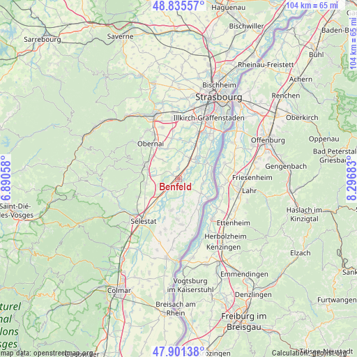
Benfeld GPS coordinates[2]
48° 22' 14.232" North, 7° 35' 37.32" East
| Map corner | latitude | longitude |
|---|---|---|
| Upper-left | 48.83557°, | 6.89058° |
| Center: | 48.37062°, | 7.5937° |
| Lower-right: | 47.90138°, | 8.29683° |
| Map W x H: | 103.9×103.9 km | = 64.6×64.6mi |
| max Lat: | 51.07786° ⇑34.1% North |
| Benfeld: | 48.37062° |
| min Lat: | ⇓65.9% South 41.3874° |
| min Long | Benfeld | max Long |
| -5.08615° | 7.5937° | 9.52242° |
| W 98.5%⇐ | ⇒1.5% E |
Elevation
Elevation of Benfeld is 161 m = 528 ft, and this is 32.7 m = 107 ft below average elevation for this country.
| Max E: |
2333 m = 7654 ft | 42% |
| Avg. | 193.7 m = 635 ft | |
| Benfeld | 161 m = 528 ft | |
Min E: |
-1 m = -3 ft | 58% |
See also: France elevation on elevation.city.
Geographical zone
Benfeld is located in North temperate zone (between Tropic of Cancer and the Arctic Circle). Distance of this North polar circle is 2022.9 km =1257 mi to North.| Distance of | km | miles | from Benfeld |
|---|---|---|---|
| North Pole | 4628.8 | 2876.2 | to North |
| Arctic Circle | 2022.9 | 1257 | to North |
| Tropic Cancer | 2772.4 | 1722.7 | to South |
| Equator | 5378.3 | 3341.9 | to South |


Nearby cities:
15 places around Benfeld: (largest is in red/bold)
• Boofzheim
7.7 km =4.8 mi,  123°
123°
• Erstein
7.8 km =4.8 mi,  40°
40°
• Herbsheim
3.6 km =2.2 mi,  130°
130°
• Huttenheim
1.8 km =1.1 mi,  220°
220°
• Kertzfeld
2.2 km =1.4 mi,  298°
298°
• Kogenheim
5.3 km =3.3 mi,  225°
225°
• Matzenheim
3.4 km =2.1 mi, 38°
• Obenheim
7.4 km =4.6 mi,  99°
99°
• Osthouse
5 km =3.1 mi,  45°
45°
• Rossfeld
3.9 km =2.4 mi,  155°
155°
• Sand
2 km =1.2 mi, 44°
• Schaeffersheim
6.7 km =4.2 mi,  18°
18°
• Sermersheim
4.1 km =2.5 mi, 227°
• Stotzheim
7.5 km =4.7 mi,  276°
276°
• Uttenheim
4.4 km =2.7 mi,  3°
3°
Sources, notices
• [Note1] Compared only with cities in France existing in our database
• [Src1] Map data: © OpenStreetMap contributors (CC-BY-SA)
• [Src2] Other city data from geonames.org with taken over terms of usage.
• [Src3] Geographical zone / Annual Mean Temperature by Robert A. Rohde @ Wikipedia
