Rethel geodata
Rethel (Grand Est) is a seat of a third-order administrative division; located in France in Europe/Paris (GMT+2) time zone. With population of 8,505 people, there are 1137 cities with bigger population in this country. Compared to other cities in France, 89.4% of cities are located further ↓South; 71.1% of cities are located further ←West and 59.1% of cities have higher elevation than Rethel. Note1
Administrative division(s):
- Level 1: Grand Est
- Level 2: Ardennes
- Level 3: Arrondissement de Rethel
- Level 4: Rethel


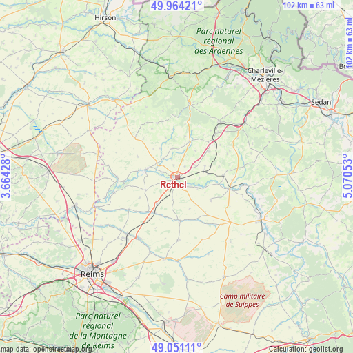
Rethel GPS coordinates[2]
49° 30' 35.244" North, 4° 22' 2.64" East
| Map corner | latitude | longitude |
|---|---|---|
| Upper-left | 49.96421°, | 3.66428° |
| Center: | 49.50979°, | 4.3674° |
| Lower-right: | 49.05111°, | 5.07053° |
| Map W x H: | 101.5×101.5 km | = 63.1×63.1mi |
| max Lat: | 51.07786° ⇑10.6% North |
| Rethel: | 49.50979° |
| min Lat: | ⇓89.4% South 41.3874° |
| min Long | Rethel | max Long |
| -5.08615° | 4.3674° | 9.52242° |
| W 71.1%⇐ | ⇒28.9% E |
Elevation
Elevation of Rethel is 105 m = 344 ft, and this is 88.7 m = 291 ft below average elevation for this country.
| Max E: |
2333 m = 7654 ft | 59.1% |
| Avg. | 193.7 m = 635 ft | |
| Rethel | 105 m = 344 ft | |
Min E: |
-1 m = -3 ft | 40.9% |
See also: France elevation on elevation.city.
Geographical zone
Rethel is located in North temperate zone (between Tropic of Cancer and the Arctic Circle). Distance of this North polar circle is 1896.2 km =1178.2 mi to North.| Distance of | km | miles | from Rethel |
|---|---|---|---|
| North Pole | 4502.1 | 2797.5 | to North |
| Arctic Circle | 1896.2 | 1178.2 | to North |
| Tropic Cancer | 2899.1 | 1801.4 | to South |
| Equator | 5505 | 3420.6 | to South |


Nearby cities:
15 places around Rethel: (largest is in red/bold)
• Acy-Romance
2.1 km =1.3 mi,  242°
242°
• Amagne
9.9 km =6.2 mi,  85°
85°
• Asfeld
18.6 km =11.6 mi,  256°
256°
• Attigny
15.6 km =9.7 mi,  102°
102°
• Château-Porcien
9 km =5.6 mi,  282°
282°
• Juniville
12.6 km =7.8 mi,  174°
174°
• Launois-sur-Vence
20.2 km =12.6 mi,  37°
37°
• Le Châtelet-sur-Retourne
12.3 km =7.6 mi,  211°
211°
• Lucquy
8.4 km =5.2 mi,  71°
71°
• Neuflize
12 km =7.5 mi,  201°
201°
• Novy-Chevrières
6.5 km =4 mi,  59°
59°
• Saint-Germainmont
17 km =10.6 mi,  269°
269°
• Saulces-Monclin
12 km =7.5 mi,  51°
51°
• Sault-lès-Rethel
1.2 km =0.7 mi, 198°
• Tagnon
9.6 km =6 mi,  215°
215°
Sources, notices
• [Note1] Compared only with cities in France existing in our database
• [Src1] Map data: © OpenStreetMap contributors (CC-BY-SA)
• [Src2] Other city data from geonames.org with taken over terms of usage.
• [Src3] Geographical zone / Annual Mean Temperature by Robert A. Rohde @ Wikipedia
