Neuflize geodata
Neuflize (Grand Est) is a populated place; located in France in Europe/Paris (GMT+2) time zone. With population of 611 people, there are 13143 cities with bigger population in this country. Compared to other cities in France, 88% of cities are located further ↓South; 70.6% of cities are located further ←West and 67% of cities have higher elevation than Neuflize. Note1
Administrative division(s):
- Level 1: Grand Est
- Level 2: Ardennes
- Level 3: Arrondissement de Rethel
- Level 4: Neuflize


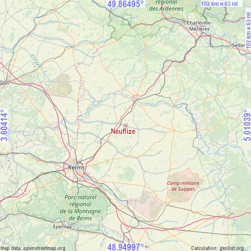
Neuflize GPS coordinates[2]
49° 24' 34.524" North, 4° 18' 26.172" East
| Map corner | latitude | longitude |
|---|---|---|
| Upper-left | 49.86495°, | 3.60414° |
| Center: | 49.40959°, | 4.30727° |
| Lower-right: | 48.94997°, | 5.01039° |
| Map W x H: | 101.7×101.7 km | = 63.2×63.2mi |
| max Lat: | 51.07786° ⇑12% North |
| Neuflize: | 49.40959° |
| min Lat: | ⇓88% South 41.3874° |
| min Long | Neuflize | max Long |
| -5.08615° | 4.30727° | 9.52242° |
| W 70.6%⇐ | ⇒29.4% E |
Elevation
Elevation of Neuflize is 85 m = 279 ft, and this is 108.7 m = 357 ft below average elevation for this country.
| Max E: |
2333 m = 7654 ft | 67% |
| Avg. | 193.7 m = 635 ft | |
| Neuflize | 85 m = 279 ft | |
Min E: |
-1 m = -3 ft | 33% |
See also: France elevation on elevation.city.
Geographical zone
Neuflize is located in North temperate zone (between Tropic of Cancer and the Arctic Circle). Distance of this North polar circle is 1907.3 km =1185.1 mi to North.| Distance of | km | miles | from Neuflize |
|---|---|---|---|
| North Pole | 4513.2 | 2804.4 | to North |
| Arctic Circle | 1907.3 | 1185.1 | to North |
| Tropic Cancer | 2887.9 | 1794.5 | to South |
| Equator | 5493.8 | 3413.7 | to South |


Nearby cities:
15 places around Neuflize: (largest is in red/bold)
• Acy-Romance
10.5 km =6.5 mi,  13°
13°
• Asfeld
15.3 km =9.5 mi,  296°
296°
• Bazancourt
11 km =6.8 mi,  243°
243°
• Boult-sur-Suippe
12.4 km =7.7 mi,  250°
250°
• Bétheniville
13.8 km =8.6 mi,  161°
161°
• Château-Porcien
13.8 km =8.6 mi,  341°
341°
• Isles-sur-Suippe
9.8 km =6.1 mi,  232°
232°
• Juniville
5.7 km =3.5 mi,  104°
104°
• Le Châtelet-sur-Retourne
2.2 km =1.4 mi,  287°
287°
• Pontfaverger-Moronvilliers
12.5 km =7.8 mi,  176°
176°
• Rethel
12 km =7.5 mi,  21°
21°
• Saint-Masmes
11.3 km =7 mi,  196°
196°
• Sault-lès-Rethel
10.8 km =6.7 mi, 21°
• Tagnon
3.6 km =2.2 mi, 338°
• Warmeriville
9 km =5.6 mi, 225°
Sources, notices
• [Note1] Compared only with cities in France existing in our database
• [Src1] Map data: © OpenStreetMap contributors (CC-BY-SA)
• [Src2] Other city data from geonames.org with taken over terms of usage.
• [Src3] Geographical zone / Annual Mean Temperature by Robert A. Rohde @ Wikipedia
