Monthermé geodata
Monthermé (Grand Est) is a populated place; located in France in Europe/Paris (GMT+2) time zone. With population of 2,806 people, there are 3473 cities with bigger population in this country. Compared to other cities in France, 92.9% of cities are located further ↓South; 74.1% of cities are located further ←West and 52.5% of cities have lower elevation than Monthermé. Note1
Administrative division(s):
- Level 1: Grand Est
- Level 2: Ardennes
- Level 3: Arrondissement de Charleville-Mézières
- Level 4: Monthermé


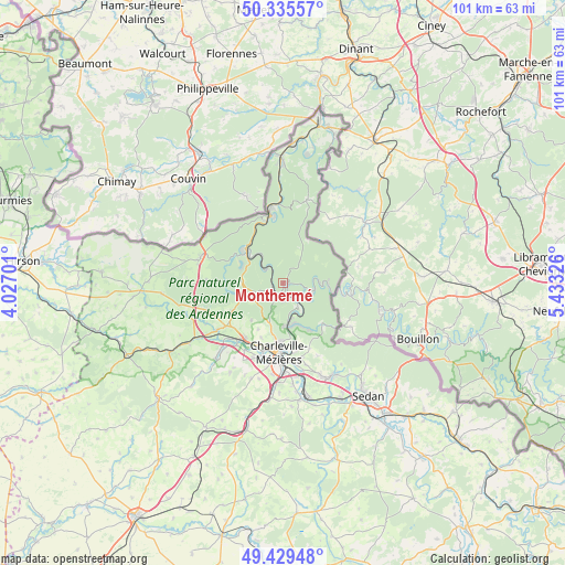
Monthermé GPS coordinates[2]
49° 53' 4.74" North, 4° 43' 48.468" East
| Map corner | latitude | longitude |
|---|---|---|
| Upper-left | 50.33557°, | 4.02701° |
| Center: | 49.88465°, | 4.73013° |
| Lower-right: | 49.42948°, | 5.43326° |
| Map W x H: | 100.7×100.7 km | = 62.6×62.6mi |
| max Lat: | 51.07786° ⇑7.1% North |
| Monthermé: | 49.88465° |
| min Lat: | ⇓92.9% South 41.3874° |
| min Long | Monthermé | max Long |
| -5.08615° | 4.73013° | 9.52242° |
| W 74.1%⇐ | ⇒25.9% E |
Elevation
Elevation of Monthermé is 141 m = 463 ft, and this is 52.7 m = 173 ft below average elevation for this country.
| Max E: |
2333 m = 7654 ft | 47.5% |
| Avg. | 193.7 m = 635 ft | |
| Monthermé | 141 m = 463 ft | |
Min E: |
-1 m = -3 ft | 52.5% |
See also: France elevation on elevation.city.
Geographical zone
Monthermé is located in North temperate zone (between Tropic of Cancer and the Arctic Circle). Distance of this North polar circle is 1854.5 km =1152.3 mi to North.| Distance of | km | miles | from Monthermé |
|---|---|---|---|
| North Pole | 4460.4 | 2771.6 | to North |
| Arctic Circle | 1854.5 | 1152.3 | to North |
| Tropic Cancer | 2940.7 | 1827.3 | to South |
| Equator | 5546.7 | 3446.6 | to South |


Nearby cities:
15 places around Monthermé: (largest is in red/bold)
• Aiglemont
11.9 km =7.4 mi,  167°
167°
• Deville
1.8 km =1.1 mi,  249°
249°
• Fumay
12 km =7.5 mi,  352°
352°
• Gespunsart
10 km =6.2 mi,  134°
134°
• Joigny-sur-Meuse
5.7 km =3.5 mi,  156°
156°
• Laifour
4.1 km =2.5 mi,  320°
320°
• Les Hautes-Rivières
8 km =5 mi,  88°
88°
• Les Mazures
7.5 km =4.7 mi,  272°
272°
• Montcy-Notre-Dame
12.2 km =7.6 mi,  175°
175°
• Neufmanil
9.5 km =5.9 mi,  149°
149°
• Nouzonville
8 km =5 mi, 171°
• Renwez
10.4 km =6.5 mi,  240°
240°
• Revin
9.2 km =5.7 mi,  312°
312°
• Thilay
5.7 km =3.5 mi,  102°
102°
• Tournes
11.8 km =7.3 mi,  213°
213°
Sources, notices
• [Note1] Compared only with cities in France existing in our database
• [Src1] Map data: © OpenStreetMap contributors (CC-BY-SA)
• [Src2] Other city data from geonames.org with taken over terms of usage.
• [Src3] Geographical zone / Annual Mean Temperature by Robert A. Rohde @ Wikipedia
