Pugey geodata
Pugey (Bourgogne-Franche-Comté) is a populated place; located in France in Europe/Paris (GMT+2) time zone. With population of 690 people, there are 11939 cities with bigger population in this country. Compared to other cities in France, 53.2% of cities are located further ↑North; 86.9% of cities are located further ←West and 87.9% of cities have lower elevation than Pugey. Note1
Administrative division(s):
- Level 1: Bourgogne-Franche-Comté
- Level 2: Doubs
- Level 3: Arrondissement de Besançon
- Level 4: Pugey


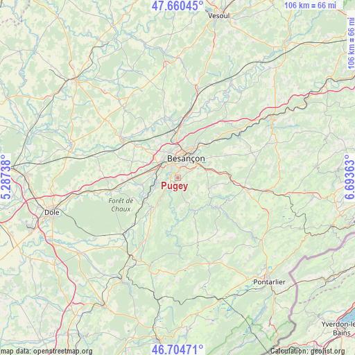
Pugey GPS coordinates[2]
47° 11' 5.028" North, 5° 59' 25.8" East
| Map corner | latitude | longitude |
|---|---|---|
| Upper-left | 47.66045°, | 5.28738° |
| Center: | 47.18473°, | 5.9905° |
| Lower-right: | 46.70471°, | 6.69363° |
| Map W x H: | 106.3×106.3 km | = 66.1×66.1mi |
| max Lat: | 51.07786° ⇑53.2% North |
| Pugey: | 47.18473° |
| min Lat: | ⇓46.8% South 41.3874° |
| min Long | Pugey | max Long |
| -5.08615° | 5.9905° | 9.52242° |
| W 86.9%⇐ | ⇒13.1% E |
Elevation
Elevation of Pugey is 386 m = 1266 ft, and this is 192.3 m = 631 ft above average elevation for this country.
| Max E: |
2333 m = 7654 ft | 12.1% |
| Pugey | 386 m 1266 ft | |
| Avg. | 193.7 m = 635 ft | |
Min E: |
-1 m = -3 ft | 87.9% |
See also: France elevation on elevation.city.
Geographical zone
Pugey is located in North temperate zone (between Tropic of Cancer and the Arctic Circle). Distance of this North polar circle is 2154.7 km =1338.9 mi to North.| Distance of | km | miles | from Pugey |
|---|---|---|---|
| North Pole | 4760.6 | 2958.1 | to North |
| Arctic Circle | 2154.7 | 1338.9 | to North |
| Tropic Cancer | 2640.5 | 1640.7 | to South |
| Equator | 5246.5 | 3260 | to South |


Nearby cities:
15 places around Pugey: (largest is in red/bold)
• Avanne-Aveney
2.5 km =1.6 mi,  313°
313°
• Besançon
7.4 km =4.6 mi,  16°
16°
• Beure
2.7 km =1.7 mi, 24°
• Boussières
7.2 km =4.5 mi,  246°
246°
• Busy
3.7 km =2.3 mi,  238°
238°
• Chemaudin
8.5 km =5.3 mi,  300°
300°
• Chenecey-Buillon
5.4 km =3.4 mi,  205°
205°
• Fontain
3.1 km =1.9 mi,  58°
58°
• Franois
6.9 km =4.3 mi,  317°
317°
• Grandfontaine
6.9 km =4.3 mi,  281°
281°
• Larnod
1.5 km =0.9 mi,  265°
265°
• Montferrand-le-Château
5.8 km =3.6 mi,  259°
259°
• Morre
7.9 km =4.9 mi,  54°
54°
• Serre-les-Sapins
8.4 km =5.2 mi,  329°
329°
• Torpes
8 km =5 mi, 255°
Sources, notices
• [Note1] Compared only with cities in France existing in our database
• [Src1] Map data: © OpenStreetMap contributors (CC-BY-SA)
• [Src2] Other city data from geonames.org with taken over terms of usage.
• [Src3] Geographical zone / Annual Mean Temperature by Robert A. Rohde @ Wikipedia
