Besançon geodata
Besançon (Bourgogne-Franche-Comté) is a seat of a second-order administrative division; located in France in Europe/Paris (GMT+2) time zone. With population of 128,426 people, there are 29 cities with bigger population in this country. Compared to other cities in France, 52.4% of cities are located further ↑North; 87.2% of cities are located further ←West and 81% of cities have lower elevation than Besançon. Note1
Administrative division(s):
- Level 1: Bourgogne-Franche-Comté
- Level 2: Doubs
- Level 3: Arrondissement de Besançon
- Level 4: Besançon


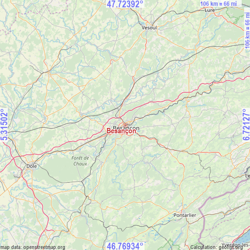
Besançon GPS coordinates[2]
47° 14' 55.608" North, 6° 1' 5.34" East
| Map corner | latitude | longitude |
|---|---|---|
| Upper-left | 47.72392°, | 5.31502° |
| Center: | 47.24878°, | 6.01815° |
| Lower-right: | 46.76934°, | 6.72127° |
| Map W x H: | 106.1×106.1 km | = 65.9×65.9mi |
| max Lat: | 51.07786° ⇑52.4% North |
| Besançon: | 47.24878° |
| min Lat: | ⇓47.6% South 41.3874° |
| min Long | Besançon | max Long |
| -5.08615° | 6.01815° | 9.52242° |
| W 87.2%⇐ | ⇒12.8% E |
Elevation
Elevation of Besançon is 300 m = 984 ft, and this is 106.3 m = 349 ft above average elevation for this country.
| Max E: |
2333 m = 7654 ft | 19% |
| Besançon | 300 m 984 ft | |
| Avg. | 193.7 m = 635 ft | |
Min E: |
-1 m = -3 ft | 81% |
See also: Besançon elevation on elevation.city.
Geographical zone
Besançon is located in North temperate zone (between Tropic of Cancer and the Arctic Circle). Distance of this North polar circle is 2147.6 km =1334.5 mi to North.| Distance of | km | miles | from Besançon |
|---|---|---|---|
| North Pole | 4753.5 | 2953.7 | to North |
| Arctic Circle | 2147.6 | 1334.5 | to North |
| Tropic Cancer | 2647.7 | 1645.2 | to South |
| Equator | 5253.6 | 3264.4 | to South |


Nearby cities:
15 places around Besançon: (largest is in red/bold)
• Auxon-Dessus
7.2 km =4.5 mi,  318°
318°
• Avanne-Aveney
6.7 km =4.2 mi,  215°
215°
• Beure
4.8 km =3 mi,  191°
191°
• Chalezeule
4.5 km =2.8 mi,  76°
76°
• Châtillon-le-Duc
6.3 km =3.9 mi,  352°
352°
• Fontain
5.5 km =3.4 mi,  174°
174°
• Franois
7.1 km =4.4 mi,  253°
253°
• Miserey-Salines
5.4 km =3.4 mi, 321°
• Montfaucon
5 km =3.1 mi,  106°
106°
• Morre
5 km =3.1 mi,  120°
120°
• Pirey
4.3 km =2.7 mi,  289°
289°
• Pouilley-les-Vignes
6.3 km =3.9 mi,  279°
279°
• Serre-les-Sapins
6.4 km =4 mi,  271°
271°
• Thise
6.2 km =3.9 mi,  49°
49°
• École-Valentin
3.3 km =2.1 mi,  307°
307°
Sources, notices
• [Note1] Compared only with cities in France existing in our database
• [Src1] Map data: © OpenStreetMap contributors (CC-BY-SA)
• [Src2] Other city data from geonames.org with taken over terms of usage.
• [Src3] Geographical zone / Annual Mean Temperature by Robert A. Rohde @ Wikipedia
