Prunay geodata
Prunay (Grand Est) is a populated place; located in France in Europe/Paris (GMT+2) time zone. With population of 864 people, there are 9950 cities with bigger population in this country. Compared to other cities in France, 84.2% of cities are located further ↓South; 69.6% of cities are located further ←West and 65.3% of cities have higher elevation than Prunay. Note1
Administrative division(s):
- Level 1: Grand Est
- Level 2: Marne
- Level 3: Arrondissement de Reims
- Level 4: Prunay


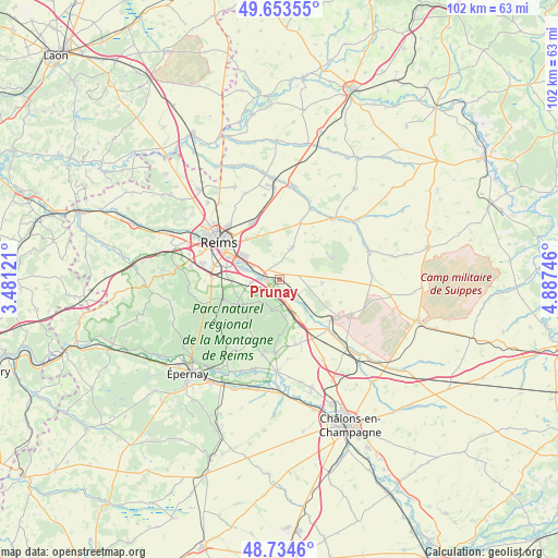
Prunay GPS coordinates[2]
49° 11' 46.356" North, 4° 11' 3.624" East
| Map corner | latitude | longitude |
|---|---|---|
| Upper-left | 49.65355°, | 3.48121° |
| Center: | 49.19621°, | 4.18434° |
| Lower-right: | 48.7346°, | 4.88746° |
| Map W x H: | 102.2×102.2 km | = 63.5×63.5mi |
| max Lat: | 51.07786° ⇑15.8% North |
| Prunay: | 49.19621° |
| min Lat: | ⇓84.2% South 41.3874° |
| min Long | Prunay | max Long |
| -5.08615° | 4.18434° | 9.52242° |
| W 69.6%⇐ | ⇒30.4% E |
Elevation
Elevation of Prunay is 89 m = 292 ft, and this is 104.7 m = 344 ft below average elevation for this country.
| Max E: |
2333 m = 7654 ft | 65.3% |
| Avg. | 193.7 m = 635 ft | |
| Prunay | 89 m = 292 ft | |
Min E: |
-1 m = -3 ft | 34.7% |
See also: France elevation on elevation.city.
Geographical zone
Prunay is located in North temperate zone (between Tropic of Cancer and the Arctic Circle). Distance of this North polar circle is 1931.1 km =1199.9 mi to North.| Distance of | km | miles | from Prunay |
|---|---|---|---|
| North Pole | 4537 | 2819.2 | to North |
| Arctic Circle | 1931.1 | 1199.9 | to North |
| Tropic Cancer | 2864.2 | 1779.7 | to South |
| Equator | 5470.1 | 3399 | to South |


Nearby cities:
15 places around Prunay: (largest is in red/bold)
• Beaumont-sur-Vesle
2.5 km =1.6 mi,  175°
175°
• Beine-Nauroy
6.3 km =3.9 mi,  21°
21°
• Cernay-lès-Reims
9.6 km =6 mi,  321°
321°
• Chigny-les-Roses
9.9 km =6.2 mi,  243°
243°
• Cormontreuil
10 km =6.2 mi,  283°
283°
• Ludes
8.9 km =5.5 mi, 238°
• Mailly-Champagne
7 km =4.3 mi,  228°
228°
• Rilly-la-Montagne
10.6 km =6.6 mi,  251°
251°
• Sept-Saulx
7.3 km =4.5 mi,  136°
136°
• Sillery
3.8 km =2.4 mi,  273°
273°
• Taissy
6.9 km =4.3 mi,  287°
287°
• Verzenay
5 km =3.1 mi,  214°
214°
• Verzy
5.8 km =3.6 mi,  194°
194°
• Villers-Marmery
6.8 km =4.2 mi,  172°
172°
• Witry-lès-Reims
11.6 km =7.2 mi,  335°
335°
Sources, notices
• [Note1] Compared only with cities in France existing in our database
• [Src1] Map data: © OpenStreetMap contributors (CC-BY-SA)
• [Src2] Other city data from geonames.org with taken over terms of usage.
• [Src3] Geographical zone / Annual Mean Temperature by Robert A. Rohde @ Wikipedia
