Chigny-les-Roses geodata
Chigny-les-Roses (Grand Est) is a populated place; located in France in Europe/Paris (GMT+2) time zone. With population of 537 people, there are 14448 cities with bigger population in this country. Compared to other cities in France, 83.4% of cities are located further ↓South; 68.4% of cities are located further ←West and 55.9% of cities have lower elevation than Chigny-les-Roses. Note1
Administrative division(s):
- Level 1: Grand Est
- Level 2: Marne
- Level 3: Arrondissement de Reims
- Level 4: Chigny-les-Roses


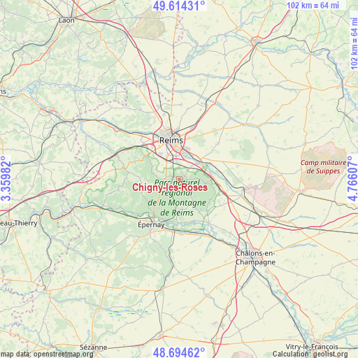
Chigny-les-Roses GPS coordinates[2]
49° 9' 23.76" North, 4° 3' 46.584" East
| Map corner | latitude | longitude |
|---|---|---|
| Upper-left | 49.61431°, | 3.35982° |
| Center: | 49.1566°, | 4.06294° |
| Lower-right: | 48.69462°, | 4.76607° |
| Map W x H: | 102.3×102.3 km | = 63.6×63.6mi |
| max Lat: | 51.07786° ⇑16.6% North |
| Chigny-les-Roses: | 49.1566° |
| min Lat: | ⇓83.4% South 41.3874° |
| min Long | Chigny-les-Rose | max Long |
| -5.08615° | 4.06294° | 9.52242° |
| W 68.4%⇐ | ⇒31.6% E |
Elevation
Elevation of Chigny-les-Roses is 153 m = 502 ft, and this is 40.7 m = 134 ft below average elevation for this country.
| Max E: |
2333 m = 7654 ft | 44.1% |
| Avg. | 193.7 m = 635 ft | |
| Chigny-les-Roses | 153 m = 502 ft | |
Min E: |
-1 m = -3 ft | 55.9% |
See also: France elevation on elevation.city.
Geographical zone
Chigny-les-Roses is located in North temperate zone (between Tropic of Cancer and the Arctic Circle). Distance of this North polar circle is 1935.5 km =1202.7 mi to North.| Distance of | km | miles | from Chigny-les-Roses |
|---|---|---|---|
| North Pole | 4541.4 | 2821.9 | to North |
| Arctic Circle | 1935.5 | 1202.7 | to North |
| Tropic Cancer | 2859.8 | 1777 | to South |
| Equator | 5465.7 | 3396.2 | to South |


Nearby cities:
15 places around Chigny-les-Roses: (largest is in red/bold)
• Avenay-Val-d’Or
9.7 km =6 mi,  186°
186°
• Beaumont-sur-Vesle
9.2 km =5.7 mi,  77°
77°
• Bezannes
9.2 km =5.7 mi,  324°
324°
• Cormontreuil
6.7 km =4.2 mi,  351°
351°
• Germaine
5.2 km =3.2 mi,  206°
206°
• Ludes
1.3 km =0.8 mi,  102°
102°
• Mailly-Champagne
3.6 km =2.2 mi,  92°
92°
• Prunay
9.9 km =6.2 mi,  63°
63°
• Rilly-la-Montagne
1.6 km =1 mi,  308°
308°
• Sermiers
5.7 km =3.5 mi,  272°
272°
• Sillery
6.9 km =4.3 mi,  47°
47°
• Taissy
6.9 km =4.3 mi,  19°
19°
• Verzenay
6 km =3.7 mi, 87°
• Verzy
7.5 km =4.7 mi, 99°
• Villers-Allerand
2.9 km =1.8 mi,  289°
289°
Sources, notices
• [Note1] Compared only with cities in France existing in our database
• [Src1] Map data: © OpenStreetMap contributors (CC-BY-SA)
• [Src2] Other city data from geonames.org with taken over terms of usage.
• [Src3] Geographical zone / Annual Mean Temperature by Robert A. Rohde @ Wikipedia
