Beine-Nauroy geodata
Beine-Nauroy (Grand Est) is a populated place; located in France in Europe/Paris (GMT+2) time zone. With population of 836 people, there are 10228 cities with bigger population in this country. Compared to other cities in France, 85.1% of cities are located further ↓South; 69.8% of cities are located further ←West and 55.9% of cities have higher elevation than Beine-Nauroy. Note1
Administrative division(s):
- Level 1: Grand Est
- Level 2: Marne
- Level 3: Arrondissement de Reims
- Level 4: Beine-Nauroy


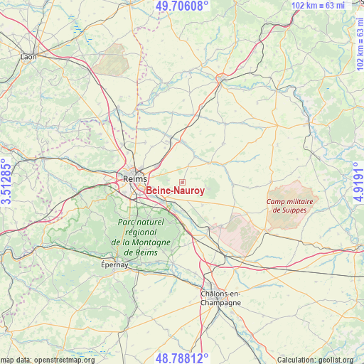
Beine-Nauroy GPS coordinates[2]
49° 14' 57.228" North, 4° 12' 57.528" East
| Map corner | latitude | longitude |
|---|---|---|
| Upper-left | 49.70608°, | 3.51285° |
| Center: | 49.24923°, | 4.21598° |
| Lower-right: | 48.78812°, | 4.9191° |
| Map W x H: | 102.1×102.1 km | = 63.4×63.4mi |
| max Lat: | 51.07786° ⇑14.9% North |
| Beine-Nauroy: | 49.24923° |
| min Lat: | ⇓85.1% South 41.3874° |
| min Long | Beine-Nauroy | max Long |
| -5.08615° | 4.21598° | 9.52242° |
| W 69.8%⇐ | ⇒30.2% E |
Elevation
Elevation of Beine-Nauroy is 114 m = 374 ft, and this is 79.7 m = 261 ft below average elevation for this country.
| Max E: |
2333 m = 7654 ft | 55.9% |
| Avg. | 193.7 m = 635 ft | |
| Beine-Nauroy | 114 m = 374 ft | |
Min E: |
-1 m = -3 ft | 44.1% |
See also: France elevation on elevation.city.
Geographical zone
Beine-Nauroy is located in North temperate zone (between Tropic of Cancer and the Arctic Circle). Distance of this North polar circle is 1925.2 km =1196.3 mi to North.| Distance of | km | miles | from Beine-Nauroy |
|---|---|---|---|
| North Pole | 4531.1 | 2815.5 | to North |
| Arctic Circle | 1925.2 | 1196.3 | to North |
| Tropic Cancer | 2870.1 | 1783.4 | to South |
| Equator | 5476 | 3402.6 | to South |


Nearby cities:
15 places around Beine-Nauroy: (largest is in red/bold)
• Beaumont-sur-Vesle
8.6 km =5.3 mi,  194°
194°
• Bétheniville
12.1 km =7.5 mi,  66°
66°
• Caurel
7.6 km =4.7 mi,  323°
323°
• Cernay-lès-Reims
8.4 km =5.2 mi,  281°
281°
• Isles-sur-Suippe
11.9 km =7.4 mi,  354°
354°
• Pontfaverger-Moronvilliers
9 km =5.6 mi,  53°
53°
• Prunay
6.3 km =3.9 mi,  201°
201°
• Saint-Masmes
7.7 km =4.8 mi,  25°
25°
• Sept-Saulx
11.5 km =7.1 mi,  166°
166°
• Sillery
8.3 km =5.2 mi,  226°
226°
• Taissy
9.6 km =6 mi,  246°
246°
• Verzenay
11.2 km =7 mi,  207°
207°
• Verzy
12.1 km =7.5 mi, 198°
• Warmeriville
11.5 km =7.1 mi,  1°
1°
• Witry-lès-Reims
8.5 km =5.3 mi,  303°
303°
Sources, notices
• [Note1] Compared only with cities in France existing in our database
• [Src1] Map data: © OpenStreetMap contributors (CC-BY-SA)
• [Src2] Other city data from geonames.org with taken over terms of usage.
• [Src3] Geographical zone / Annual Mean Temperature by Robert A. Rohde @ Wikipedia
