Précieux geodata
Précieux (Auvergne-Rhône-Alpes) is a populated place; located in France in Europe/Paris (GMT+2) time zone. With population of 1,013 people, there are 8749 cities with bigger population in this country. Compared to other cities in France, 72.8% of cities are located further ↑North; 69.3% of cities are located further ←West and 86.9% of cities have lower elevation than Précieux. Note1
Administrative division(s):
- Level 1: Auvergne-Rhône-Alpes
- Level 2: Département de la Loire
- Level 3: Arrondissement de Montbrison
- Level 4: Précieux


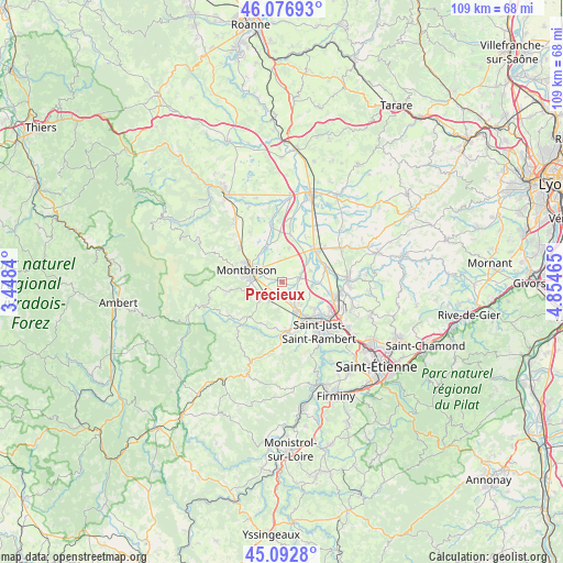
Précieux GPS coordinates[2]
45° 35' 13.272" North, 4° 9' 5.472" East
| Map corner | latitude | longitude |
|---|---|---|
| Upper-left | 46.07693°, | 3.4484° |
| Center: | 45.58702°, | 4.15152° |
| Lower-right: | 45.0928°, | 4.85465° |
| Map W x H: | 109.4×109.4 km | = 68×68mi |
| max Lat: | 51.07786° ⇑72.8% North |
| Précieux: | 45.58702° |
| min Lat: | ⇓27.2% South 41.3874° |
| min Long | Précieux | max Long |
| -5.08615° | 4.15152° | 9.52242° |
| W 69.3%⇐ | ⇒30.7% E |
Elevation
Elevation of Précieux is 371 m = 1217 ft, and this is 177.3 m = 582 ft above average elevation for this country.
| Max E: |
2333 m = 7654 ft | 13.1% |
| Précieux | 371 m 1217 ft | |
| Avg. | 193.7 m = 635 ft | |
Min E: |
-1 m = -3 ft | 86.9% |
See also: France elevation on elevation.city.
Geographical zone
Précieux is located in North temperate zone (between Tropic of Cancer and the Arctic Circle). Distance of this North polar circle is 2332.4 km =1449.3 mi to North.| Distance of | km | miles | from Précieux |
|---|---|---|---|
| North Pole | 4938.3 | 3068.5 | to North |
| Arctic Circle | 2332.4 | 1449.3 | to North |
| Tropic Cancer | 2462.9 | 1530.4 | to South |
| Equator | 5068.8 | 3149.6 | to South |


Nearby cities:
15 places around Précieux: (largest is in red/bold)
• Boisset-Saint-Priest
9 km =5.6 mi,  204°
204°
• Boisset-lès-Montrond
6.5 km =4 mi,  47°
47°
• Bonson
8.6 km =5.3 mi,  146°
146°
• Craintilleux
6 km =3.7 mi,  94°
94°
• Cuzieu
8.6 km =5.3 mi,  74°
74°
• Lézigneux
7.1 km =4.4 mi,  250°
250°
• Montbrison
7.1 km =4.4 mi,  288°
288°
• Montrond-les-Bains
9.2 km =5.7 mi, 46°
• Saint-Cyprien
8.7 km =5.4 mi,  132°
132°
• Saint-Georges-Haute-Ville
5.3 km =3.3 mi,  231°
231°
• Saint-Romain-le-Puy
3.9 km =2.4 mi,  214°
214°
• Saint-Thomas-la-Garde
6 km =3.7 mi, 247°
• Savigneux
6.2 km =3.9 mi,  301°
301°
• Sury-le-Comtal
6.1 km =3.8 mi, 154°
• Veauchette
9.1 km =5.7 mi,  107°
107°
Sources, notices
• [Note1] Compared only with cities in France existing in our database
• [Src1] Map data: © OpenStreetMap contributors (CC-BY-SA)
• [Src2] Other city data from geonames.org with taken over terms of usage.
• [Src3] Geographical zone / Annual Mean Temperature by Robert A. Rohde @ Wikipedia
