Bonson geodata
Bonson (Auvergne-Rhône-Alpes) is a populated place; located in France in Europe/Paris (GMT+2) time zone. With population of 3,881 people, there are 2533 cities with bigger population in this country. Compared to other cities in France, 73.9% of cities are located further ↑North; 69.8% of cities are located further ←West and 87.3% of cities have lower elevation than Bonson. Note1
Administrative division(s):
- Level 1: Auvergne-Rhône-Alpes
- Level 2: Département de la Loire
- Level 3: Arrondissement de Montbrison
- Level 4: Bonson


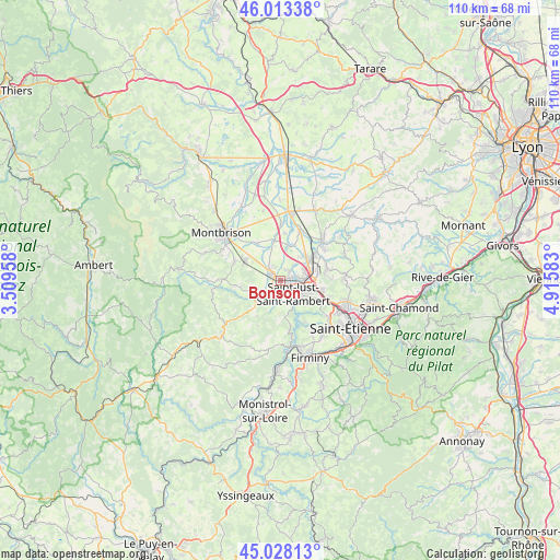
Bonson GPS coordinates[2]
45° 31' 22.476" North, 4° 12' 45.72" East
| Map corner | latitude | longitude |
|---|---|---|
| Upper-left | 46.01338°, | 3.50958° |
| Center: | 45.52291°, | 4.2127° |
| Lower-right: | 45.02813°, | 4.91583° |
| Map W x H: | 109.5×109.5 km | = 68×68mi |
| max Lat: | 51.07786° ⇑73.9% North |
| Bonson: | 45.52291° |
| min Lat: | ⇓26.1% South 41.3874° |
| min Long | Bonson | max Long |
| -5.08615° | 4.2127° | 9.52242° |
| W 69.8%⇐ | ⇒30.2% E |
Elevation
Elevation of Bonson is 378 m = 1240 ft, and this is 184.3 m = 605 ft above average elevation for this country.
| Max E: |
2333 m = 7654 ft | 12.7% |
| Bonson | 378 m 1240 ft | |
| Avg. | 193.7 m = 635 ft | |
Min E: |
-1 m = -3 ft | 87.3% |
See also: France elevation on elevation.city.
Geographical zone
Bonson is located in North temperate zone (between Tropic of Cancer and the Arctic Circle). Distance of this North polar circle is 2339.5 km =1453.7 mi to North.| Distance of | km | miles | from Bonson |
|---|---|---|---|
| North Pole | 4945.4 | 3072.9 | to North |
| Arctic Circle | 2339.5 | 1453.7 | to North |
| Tropic Cancer | 2455.8 | 1526 | to South |
| Equator | 5061.7 | 3145.2 | to South |


Nearby cities:
15 places around Bonson: (largest is in red/bold)
• Andrézieux-Bouthéon
3.7 km =2.3 mi,  84°
84°
• Boisset-Saint-Priest
8.5 km =5.3 mi,  262°
262°
• Chambles
8.8 km =5.5 mi,  169°
169°
• Craintilleux
6.7 km =4.2 mi,  10°
10°
• La Fouillouse
8.2 km =5.1 mi,  104°
104°
• Précieux
8.6 km =5.3 mi,  326°
326°
• Saint-Bonnet-les-Oules
9.2 km =5.7 mi,  71°
71°
• Saint-Cyprien
2.1 km =1.3 mi,  52°
52°
• Saint-Georges-Haute-Ville
9.7 km =6 mi,  293°
293°
• Saint-Just-Saint-Rambert
3.4 km =2.1 mi,  139°
139°
• Saint-Marcellin-en-Forez
4.3 km =2.7 mi,  227°
227°
• Saint-Romain-le-Puy
8 km =5 mi,  299°
299°
• Sury-le-Comtal
2.6 km =1.6 mi,  307°
307°
• Veauche
7.6 km =4.7 mi, 53°
• Veauchette
5.9 km =3.7 mi,  41°
41°
Sources, notices
• [Note1] Compared only with cities in France existing in our database
• [Src1] Map data: © OpenStreetMap contributors (CC-BY-SA)
• [Src2] Other city data from geonames.org with taken over terms of usage.
• [Src3] Geographical zone / Annual Mean Temperature by Robert A. Rohde @ Wikipedia
