Porcheville geodata
Porcheville (Île-de-France) is a populated place; located in France in Europe/Paris (GMT+2) time zone. With population of 2,630 people, there are 3705 cities with bigger population in this country. Compared to other cities in France, 79% of cities are located further ↓South; 59.6% of cities are located further →East and 91.2% of cities have higher elevation than Porcheville. Note1
Administrative division(s):
- Level 1: Île-de-France
- Level 2: Yvelines
- Level 3: Arrondissement de Mantes-la-Jolie
- Level 4: Porcheville


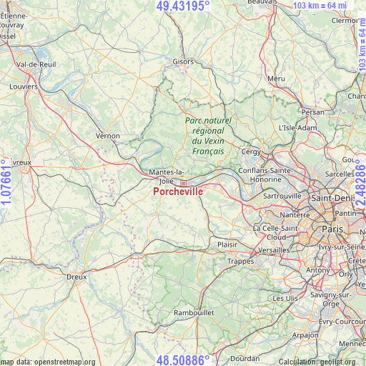
Porcheville GPS coordinates[2]
48° 58' 21.144" North, 1° 46' 47.028" East
| Map corner | latitude | longitude |
|---|---|---|
| Upper-left | 49.43195°, | 1.07661° |
| Center: | 48.97254°, | 1.77973° |
| Lower-right: | 48.50886°, | 2.48286° |
| Map W x H: | 102.6×102.6 km | = 63.8×63.8mi |
| max Lat: | 51.07786° ⇑21% North |
| Porcheville: | 48.97254° |
| min Lat: | ⇓79% South 41.3874° |
| min Long | Porcheville | max Long |
| -5.08615° | 1.77973° | 9.52242° |
| W 40.4%⇐ | ⇒59.6% E |
Elevation
Elevation of Porcheville is 27 m = 89 ft, and this is 166.7 m = 547 ft below average elevation for this country.
| Max E: |
2333 m = 7654 ft | 91.2% |
| Avg. | 193.7 m = 635 ft | |
| Porcheville | 27 m = 89 ft | |
Min E: |
-1 m = -3 ft | 8.8% |
See also: France elevation on elevation.city.
Geographical zone
Porcheville is located in North temperate zone (between Tropic of Cancer and the Arctic Circle). Distance of this North polar circle is 1955.9 km =1215.3 mi to North.| Distance of | km | miles | from Porcheville |
|---|---|---|---|
| North Pole | 4561.8 | 2834.6 | to North |
| Arctic Circle | 1955.9 | 1215.3 | to North |
| Tropic Cancer | 2839.3 | 1764.3 | to South |
| Equator | 5445.2 | 3383.5 | to South |


Nearby cities:
15 places around Porcheville: (largest is in red/bold)
• Aubergenville
5.6 km =3.5 mi,  104°
104°
• Auffreville-Brasseuil
5.5 km =3.4 mi,  248°
248°
• Breuil-Bois-Robert
5.5 km =3.4 mi,  236°
236°
• Gargenville
2.9 km =1.8 mi,  53°
53°
• Guerville
4.6 km =2.9 mi,  226°
226°
• Guitrancourt
4.1 km =2.5 mi,  356°
356°
• Issou
2.2 km =1.4 mi,  26°
26°
• Juziers
5.4 km =3.4 mi,  67°
67°
• La Falaise
4.9 km =3 mi,  131°
131°
• Limay
3.8 km =2.4 mi,  311°
311°
• Mantes-la-Jolie
5 km =3.1 mi,  293°
293°
• Mantes-la-Ville
5.6 km =3.5 mi,  271°
271°
• Mézières-sur-Seine
1.6 km =1 mi,  143°
143°
• Nézel
5.3 km =3.3 mi, 125°
• Épône
3.7 km =2.3 mi,  122°
122°
Sources, notices
• [Note1] Compared only with cities in France existing in our database
• [Src1] Map data: © OpenStreetMap contributors (CC-BY-SA)
• [Src2] Other city data from geonames.org with taken over terms of usage.
• [Src3] Geographical zone / Annual Mean Temperature by Robert A. Rohde @ Wikipedia
