Plouguerneau geodata
Plouguerneau (Brittany) is a populated place; located in France in Europe/Paris (GMT+2) time zone. With population of 5,883 people, there are 1680 cities with bigger population in this country. Compared to other cities in France, 70.8% of cities are located further ↓South; 99.8% of cities are located further →East and 81.1% of cities have higher elevation than Plouguerneau. Note1
Administrative division(s):
- Level 1: Brittany
- Level 2: Département du Finistère
- Level 3: Arrondissement de Brest
- Level 4: Plouguerneau


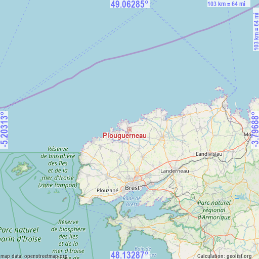
Plouguerneau GPS coordinates[2]
48° 36' 0" North, 4° 30' 0" West
| Map corner | latitude | longitude |
|---|---|---|
| Upper-left | 49.06285°, | -5.20313° |
| Center: | 48.6°, | -4.5° |
| Lower-right: | 48.13287°, | -3.79688° |
| Map W x H: | 103.4×103.4 km | = 64.2×64.2mi |
| max Lat: | 51.07786° ⇑29.2% North |
| Plouguerneau: | 48.6° |
| min Lat: | ⇓70.8% South 41.3874° |
| min Long | Plouguerneau | max Long |
| -5.08615° | -4.5° | 9.52242° |
| W 0.2%⇐ | ⇒99.8% E |
Elevation
Elevation of Plouguerneau is 52 m = 171 ft, and this is 141.7 m = 465 ft below average elevation for this country.
| Max E: |
2333 m = 7654 ft | 81.1% |
| Avg. | 193.7 m = 635 ft | |
| Plouguerneau | 52 m = 171 ft | |
Min E: |
-1 m = -3 ft | 18.9% |
See also: France elevation on elevation.city.
Geographical zone
Plouguerneau is located in North temperate zone (between Tropic of Cancer and the Arctic Circle). Distance of this North polar circle is 1997.4 km =1241.1 mi to North.| Distance of | km | miles | from Plouguerneau |
|---|---|---|---|
| North Pole | 4603.2 | 2860.3 | to North |
| Arctic Circle | 1997.4 | 1241.1 | to North |
| Tropic Cancer | 2797.9 | 1738.5 | to South |
| Equator | 5403.8 | 3357.8 | to South |


Nearby cities:
15 places around Plouguerneau: (largest is in red/bold)
• Bourg-Blanc
11.3 km =7 mi,  181°
181°
• Coat-Méal
10.6 km =6.6 mi,  196°
196°
• Guissény
7.6 km =4.7 mi,  61°
61°
• Kerlouan
11.1 km =6.9 mi, 63°
• Kernilis
6.9 km =4.3 mi,  118°
118°
• Kernouës
11.2 km =7 mi,  96°
96°
• Landéda
5.4 km =3.4 mi,  254°
254°
• Lannilis
3.6 km =2.2 mi,  206°
206°
• Le Drennec
12 km =7.5 mi,  127°
127°
• Plabennec
12.1 km =7.5 mi,  153°
153°
• Plouguin
10.4 km =6.5 mi,  224°
224°
• Plouvien
8.3 km =5.2 mi, 153°
• Saint-Frégant
8.6 km =5.3 mi,  90°
90°
• Saint-Pabu
8.2 km =5.1 mi,  243°
243°
• Tréglonou
6.1 km =3.8 mi, 203°
Sources, notices
• [Note1] Compared only with cities in France existing in our database
• [Src1] Map data: © OpenStreetMap contributors (CC-BY-SA)
• [Src2] Other city data from geonames.org with taken over terms of usage.
• [Src3] Geographical zone / Annual Mean Temperature by Robert A. Rohde @ Wikipedia
