Guissény geodata
Guissény (Brittany) is a populated place; located in France in Europe/Paris (GMT+2) time zone. With population of 1,938 people, there are 4941 cities with bigger population in this country. Compared to other cities in France, 71.6% of cities are located further ↓South; 99.7% of cities are located further →East and 95.4% of cities have higher elevation than Guissény. Note1
Administrative division(s):
- Level 1: Brittany
- Level 2: Département du Finistère
- Level 3: Arrondissement de Brest
- Level 4: Guissény


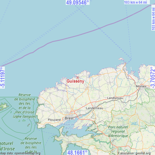
Guissény GPS coordinates[2]
48° 37' 58.512" North, 4° 24' 31.824" West
| Map corner | latitude | longitude |
|---|---|---|
| Upper-left | 49.09546°, | -5.11197° |
| Center: | 48.63292°, | -4.40884° |
| Lower-right: | 48.1661°, | -3.70572° |
| Map W x H: | 103.3×103.3 km | = 64.2×64.2mi |
| max Lat: | 51.07786° ⇑28.4% North |
| Guissény: | 48.63292° |
| min Lat: | ⇓71.6% South 41.3874° |
| min Long | Guissény | max Long |
| -5.08615° | -4.40884° | 9.52242° |
| W 0.3%⇐ | ⇒99.7% E |
Elevation
Elevation of Guissény is 16 m = 52 ft, and this is 177.7 m = 583 ft below average elevation for this country.
| Max E: |
2333 m = 7654 ft | 95.4% |
| Avg. | 193.7 m = 635 ft | |
| Guissény | 16 m = 52 ft | |
Min E: |
-1 m = -3 ft | 4.6% |
See also: France elevation on elevation.city.
Geographical zone
Guissény is located in North temperate zone (between Tropic of Cancer and the Arctic Circle). Distance of this North polar circle is 1993.7 km =1238.8 mi to North.| Distance of | km | miles | from Guissény |
|---|---|---|---|
| North Pole | 4599.6 | 2858.1 | to North |
| Arctic Circle | 1993.7 | 1238.8 | to North |
| Tropic Cancer | 2801.6 | 1740.8 | to South |
| Equator | 5407.5 | 3360.1 | to South |


Nearby cities:
15 places around Guissény: (largest is in red/bold)
• Brignogan-Plage
8 km =5 mi,  60°
60°
• Kerlouan
3.5 km =2.2 mi,  67°
67°
• Kernilis
6.9 km =4.3 mi,  185°
185°
• Kernouës
6.6 km =4.1 mi,  137°
137°
• Lannilis
10.8 km =6.7 mi,  230°
230°
• Le Drennec
11.3 km =7 mi,  165°
165°
• Le Folgoët
9.4 km =5.8 mi,  145°
145°
• Lesneven
9.3 km =5.8 mi, 136°
• Ploudaniel
13 km =8.1 mi, 148°
• Plouguerneau
7.6 km =4.7 mi,  241°
241°
• Plouider
8.2 km =5.1 mi,  102°
102°
• Plounéour-Trez
7 km =4.3 mi, 74°
• Plouvien
11.5 km =7.1 mi,  195°
195°
• Saint-Frégant
4.1 km =2.5 mi, 152°
• Tréflez
10.6 km =6.6 mi, 99°
Sources, notices
• [Note1] Compared only with cities in France existing in our database
• [Src1] Map data: © OpenStreetMap contributors (CC-BY-SA)
• [Src2] Other city data from geonames.org with taken over terms of usage.
• [Src3] Geographical zone / Annual Mean Temperature by Robert A. Rohde @ Wikipedia
