Ploubezre geodata
Ploubezre (Brittany) is a populated place; located in France in Europe/Paris (GMT+2) time zone. With population of 2,762 people, there are 3537 cities with bigger population in this country. Compared to other cities in France, 73.2% of cities are located further ↓South; 98.2% of cities are located further →East and 67.8% of cities have higher elevation than Ploubezre. Note1
Administrative division(s):
- Level 1: Brittany
- Level 2: Département des Côtes-d’Armor
- Level 3: Arrondissement de Lannion
- Level 4: Ploubezre


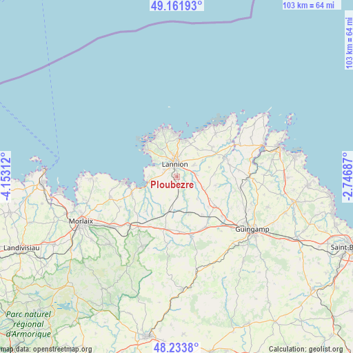
Ploubezre GPS coordinates[2]
48° 42' 0" North, 3° 27' 0" West
| Map corner | latitude | longitude |
|---|---|---|
| Upper-left | 49.16193°, | -4.15312° |
| Center: | 48.7°, | -3.45° |
| Lower-right: | 48.2338°, | -2.74687° |
| Map W x H: | 103.2×103.2 km | = 64.1×64.1mi |
| max Lat: | 51.07786° ⇑26.8% North |
| Ploubezre: | 48.7° |
| min Lat: | ⇓73.2% South 41.3874° |
| min Long | Ploubezre | max Long |
| -5.08615° | -3.45° | 9.52242° |
| W 1.8%⇐ | ⇒98.2% E |
Elevation
Elevation of Ploubezre is 83 m = 272 ft, and this is 110.7 m = 363 ft below average elevation for this country.
| Max E: |
2333 m = 7654 ft | 67.8% |
| Avg. | 193.7 m = 635 ft | |
| Ploubezre | 83 m = 272 ft | |
Min E: |
-1 m = -3 ft | 32.2% |
See also: France elevation on elevation.city.
Geographical zone
Ploubezre is located in North temperate zone (between Tropic of Cancer and the Arctic Circle). Distance of this North polar circle is 1986.2 km =1234.2 mi to North.| Distance of | km | miles | from Ploubezre |
|---|---|---|---|
| North Pole | 4592.1 | 2853.4 | to North |
| Arctic Circle | 1986.2 | 1234.2 | to North |
| Tropic Cancer | 2809 | 1745.4 | to South |
| Equator | 5414.9 | 3364.7 | to South |


Nearby cities:
15 places around Ploubezre: (largest is in red/bold)
• Caouënnec-Lanvézéac
6.1 km =3.8 mi,  90°
90°
• Cavan
8.2 km =5.1 mi,  111°
111°
• Kermaria-Sulard
9.9 km =6.2 mi,  36°
36°
• Lannion
3.6 km =2.2 mi,  353°
353°
• Lanvellec
11 km =6.8 mi,  215°
215°
• Locquémeau
8.7 km =5.4 mi,  288°
288°
• Louannec
10.8 km =6.7 mi,  14°
14°
• Pleumeur-Bodou
8.9 km =5.5 mi,  326°
326°
• Plouaret
9.3 km =5.8 mi,  187°
187°
• Ploumilliau
5.2 km =3.2 mi,  249°
249°
• Pluzunet
8.8 km =5.5 mi,  138°
138°
• Rospez
5.9 km =3.7 mi,  56°
56°
• Saint-Quay-Perros
9.3 km =5.8 mi,  0°
0°
• Tonquédec
5.2 km =3.2 mi,  131°
131°
• Trédrez-Locquémeau
8.6 km =5.3 mi,  270°
270°
Sources, notices
• [Note1] Compared only with cities in France existing in our database
• [Src1] Map data: © OpenStreetMap contributors (CC-BY-SA)
• [Src2] Other city data from geonames.org with taken over terms of usage.
• [Src3] Geographical zone / Annual Mean Temperature by Robert A. Rohde @ Wikipedia
