Douarnenez geodata
Douarnenez (Brittany) is a populated place; located in France in Europe/Paris (GMT+2) time zone. With population of 16,590 people, there are 572 cities with bigger population in this country. Compared to other cities in France, 61% of cities are located further ↓South; 99.6% of cities are located further →East and 92.7% of cities have higher elevation than Douarnenez. Note1
Administrative division(s):
- Level 1: Brittany
- Level 2: Département du Finistère
- Level 3: Arrondissement de Quimper
- Level 4: Douarnenez


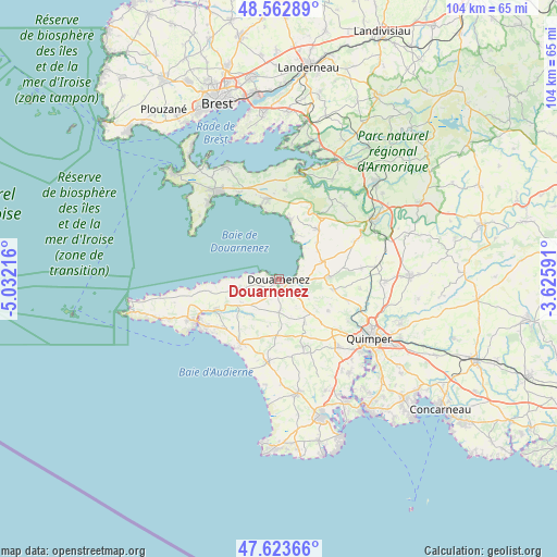
Douarnenez GPS coordinates[2]
48° 5' 43.512" North, 4° 19' 44.544" West
| Map corner | latitude | longitude |
|---|---|---|
| Upper-left | 48.56289°, | -5.03216° |
| Center: | 48.09542°, | -4.32904° |
| Lower-right: | 47.62366°, | -3.62591° |
| Map W x H: | 104.4×104.4 km | = 64.9×64.9mi |
| max Lat: | 51.07786° ⇑39% North |
| Douarnenez: | 48.09542° |
| min Lat: | ⇓61% South 41.3874° |
| min Long | Douarnenez | max Long |
| -5.08615° | -4.32904° | 9.52242° |
| W 0.4%⇐ | ⇒99.6% E |
Elevation
Elevation of Douarnenez is 23 m = 75 ft, and this is 170.7 m = 560 ft below average elevation for this country.
| Max E: |
2333 m = 7654 ft | 92.7% |
| Avg. | 193.7 m = 635 ft | |
| Douarnenez | 23 m = 75 ft | |
Min E: |
-1 m = -3 ft | 7.3% |
See also: France elevation on elevation.city.
Geographical zone
Douarnenez is located in North temperate zone (between Tropic of Cancer and the Arctic Circle). Distance of this North polar circle is 2053.5 km =1276 mi to North.| Distance of | km | miles | from Douarnenez |
|---|---|---|---|
| North Pole | 4659.4 | 2895.2 | to North |
| Arctic Circle | 2053.5 | 1276 | to North |
| Tropic Cancer | 2741.8 | 1703.7 | to South |
| Equator | 5347.7 | 3322.9 | to South |


Nearby cities:
15 places around Douarnenez: (largest is in red/bold)
• Confort-Meilars
9.2 km =5.7 mi,  236°
236°
• Gourlizon
9.7 km =6 mi,  151°
151°
• Guengat
11 km =6.8 mi,  122°
122°
• Kerlaz
4.3 km =2.7 mi,  96°
96°
• Landudec
10.6 km =6.6 mi,  182°
182°
• Le Juch
6.4 km =4 mi, 120°
• Locronan
9 km =5.6 mi,  87°
87°
• Mahalon
10.4 km =6.5 mi,  229°
229°
• Plogonnec
10.9 km =6.8 mi, 97°
• Plomodiern
12.1 km =7.5 mi,  35°
35°
• Plonéis
12.1 km =7.5 mi,  136°
136°
• Plonévez-Porzay
8.4 km =5.2 mi, 86°
• Pouldergat
5.1 km =3.2 mi, 183°
• Poullan-sur-Mer
6.6 km =4.1 mi,  258°
258°
• Saint-Nic
12.1 km =7.5 mi,  16°
16°
Sources, notices
• [Note1] Compared only with cities in France existing in our database
• [Src1] Map data: © OpenStreetMap contributors (CC-BY-SA)
• [Src2] Other city data from geonames.org with taken over terms of usage.
• [Src3] Geographical zone / Annual Mean Temperature by Robert A. Rohde @ Wikipedia
