Plesder geodata
Plesder (Brittany) is a populated place; located in France in Europe/Paris (GMT+2) time zone. With population of 612 people, there are 13126 cities with bigger population in this country. Compared to other cities in France, 66.6% of cities are located further ↓South; 94.5% of cities are located further →East and 72.3% of cities have higher elevation than Plesder. Note1
Administrative division(s):
- Level 1: Brittany
- Level 2: Département d'Ille-et-Vilaine
- Level 3: Arrondissement de Saint-Malo
- Level 4: Plesder


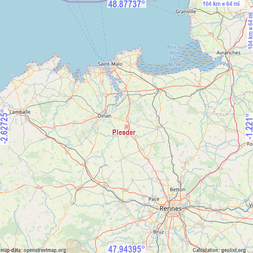
Plesder GPS coordinates[2]
48° 24' 46.08" North, 1° 55' 26.868" West
| Map corner | latitude | longitude |
|---|---|---|
| Upper-left | 48.87737°, | -2.62725° |
| Center: | 48.4128°, | -1.92413° |
| Lower-right: | 47.94395°, | -1.221° |
| Map W x H: | 103.8×103.8 km | = 64.5×64.5mi |
| max Lat: | 51.07786° ⇑33.4% North |
| Plesder: | 48.4128° |
| min Lat: | ⇓66.6% South 41.3874° |
| min Long | Plesder | max Long |
| -5.08615° | -1.92413° | 9.52242° |
| W 5.5%⇐ | ⇒94.5% E |
Elevation
Elevation of Plesder is 73 m = 240 ft, and this is 120.7 m = 396 ft below average elevation for this country.
| Max E: |
2333 m = 7654 ft | 72.3% |
| Avg. | 193.7 m = 635 ft | |
| Plesder | 73 m = 240 ft | |
Min E: |
-1 m = -3 ft | 27.7% |
See also: France elevation on elevation.city.
Geographical zone
Plesder is located in North temperate zone (between Tropic of Cancer and the Arctic Circle). Distance of this North polar circle is 2018.2 km =1254.1 mi to North.| Distance of | km | miles | from Plesder |
|---|---|---|---|
| North Pole | 4624.1 | 2873.3 | to North |
| Arctic Circle | 2018.2 | 1254.1 | to North |
| Tropic Cancer | 2777.1 | 1725.6 | to South |
| Equator | 5383 | 3344.8 | to South |


Nearby cities:
15 places around Plesder: (largest is in red/bold)
• La Vicomté-sur-Rance
9.7 km =6 mi,  334°
334°
• Lanhélin
8.7 km =5.4 mi,  54°
54°
• Lanvallay
9 km =5.6 mi,  301°
301°
• Le Tronchet
10.4 km =6.5 mi,  38°
38°
• Les Champs-Géraux
3.5 km =2.2 mi,  276°
276°
• Léhon
9.6 km =6 mi,  291°
291°
• Meillac
8.1 km =5 mi,  90°
90°
• Pleugueneuc
2.3 km =1.4 mi,  137°
137°
• Saint-Domineuc
5.8 km =3.6 mi, 141°
• Saint-Hélen
6.9 km =4.3 mi,  338°
338°
• Saint-Pierre-de-Plesguen
3.8 km =2.4 mi,  12°
12°
• Saint-Thual
8.5 km =5.3 mi,  184°
184°
• Taden
9.9 km =6.2 mi,  314°
314°
• Trévérien
4.7 km =2.9 mi, 184°
• Évran
5.6 km =3.5 mi,  228°
228°
Sources, notices
• [Note1] Compared only with cities in France existing in our database
• [Src1] Map data: © OpenStreetMap contributors (CC-BY-SA)
• [Src2] Other city data from geonames.org with taken over terms of usage.
• [Src3] Geographical zone / Annual Mean Temperature by Robert A. Rohde @ Wikipedia
