Évran geodata
Évran (Brittany) is a populated place; located in France in Europe/Paris (GMT+2) time zone. With population of 1,561 people, there are 5964 cities with bigger population in this country. Compared to other cities in France, 66% of cities are located further ↓South; 94.8% of cities are located further →East and 93.6% of cities have higher elevation than Évran. Note1
Administrative division(s):
- Level 1: Brittany
- Level 2: Département des Côtes-d’Armor
- Level 3: Arrondissement de Dinan
- Level 4: Évran


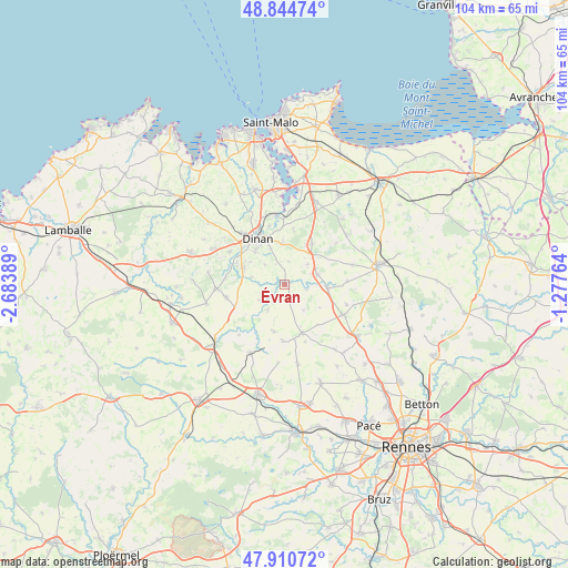
Évran GPS coordinates[2]
48° 22' 47.532" North, 1° 58' 50.736" West
| Map corner | latitude | longitude |
|---|---|---|
| Upper-left | 48.84474°, | -2.68389° |
| Center: | 48.37987°, | -1.98076° |
| Lower-right: | 47.91072°, | -1.27764° |
| Map W x H: | 103.9×103.9 km | = 64.6×64.6mi |
| max Lat: | 51.07786° ⇑34% North |
| Évran: | 48.37987° |
| min Lat: | ⇓66% South 41.3874° |
| min Long | Évran | max Long |
| -5.08615° | -1.98076° | 9.52242° |
| W 5.2%⇐ | ⇒94.8% E |
Elevation
Elevation of Évran is 21 m = 69 ft, and this is 172.7 m = 567 ft below average elevation for this country.
| Max E: |
2333 m = 7654 ft | 93.6% |
| Avg. | 193.7 m = 635 ft | |
| Évran | 21 m = 69 ft | |
Min E: |
-1 m = -3 ft | 6.4% |
See also: France elevation on elevation.city.
Geographical zone
Évran is located in North temperate zone (between Tropic of Cancer and the Arctic Circle). Distance of this North polar circle is 2021.8 km =1256.3 mi to North.| Distance of | km | miles | from Évran |
|---|---|---|---|
| North Pole | 4627.7 | 2875.5 | to North |
| Arctic Circle | 2021.8 | 1256.3 | to North |
| Tropic Cancer | 2773.4 | 1723.3 | to South |
| Equator | 5379.3 | 3342.5 | to South |


Nearby cities:
15 places around Évran: (largest is in red/bold)
• La Baussaine
9.6 km =6 mi,  140°
140°
• Lanvallay
9.1 km =5.7 mi,  337°
337°
• Le Hinglé
7.4 km =4.6 mi,  281°
281°
• Les Champs-Géraux
4.1 km =2.5 mi,  10°
10°
• Léhon
8.6 km =5.3 mi,  326°
326°
• Plesder
5.6 km =3.5 mi,  48°
48°
• Pleugueneuc
6.1 km =3.8 mi,  71°
71°
• Plouasne
9 km =5.6 mi,  192°
192°
• Saint-Carné
7.6 km =4.7 mi,  301°
301°
• Saint-Domineuc
7.8 km =4.8 mi,  96°
96°
• Saint-Juvat
5.5 km =3.4 mi,  237°
237°
• Saint-Pierre-de-Plesguen
8.9 km =5.5 mi,  34°
34°
• Saint-Thual
5.9 km =3.7 mi, 143°
• Trévron
6.2 km =3.9 mi, 282°
• Trévérien
3.9 km =2.4 mi, 104°
Sources, notices
• [Note1] Compared only with cities in France existing in our database
• [Src1] Map data: © OpenStreetMap contributors (CC-BY-SA)
• [Src2] Other city data from geonames.org with taken over terms of usage.
• [Src3] Geographical zone / Annual Mean Temperature by Robert A. Rohde @ Wikipedia
