Perros-Guirec geodata
Perros-Guirec (Brittany) is a populated place; located in France in Europe/Paris (GMT+2) time zone. With population of 8,062 people, there are 1204 cities with bigger population in this country. Compared to other cities in France, 75.8% of cities are located further ↓South; 98.2% of cities are located further →East and 82.2% of cities have higher elevation than Perros-Guirec. Note1
Administrative division(s):
- Level 1: Brittany
- Level 2: Département des Côtes-d’Armor
- Level 3: Arrondissement de Lannion
- Level 4: Perros-Guirec


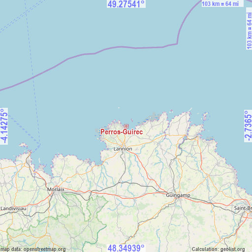
Perros-Guirec GPS coordinates[2]
48° 48' 52.344" North, 3° 26' 22.668" West
| Map corner | latitude | longitude |
|---|---|---|
| Upper-left | 49.27541°, | -4.14275° |
| Center: | 48.81454°, | -3.43963° |
| Lower-right: | 48.34939°, | -2.7365° |
| Map W x H: | 103×103 km | = 64×64mi |
| max Lat: | 51.07786° ⇑24.2% North |
| Perros-Guirec: | 48.81454° |
| min Lat: | ⇓75.8% South 41.3874° |
| min Long | Perros-Guirec | max Long |
| -5.08615° | -3.43963° | 9.52242° |
| W 1.8%⇐ | ⇒98.2% E |
Elevation
Elevation of Perros-Guirec is 49 m = 161 ft, and this is 144.7 m = 475 ft below average elevation for this country.
| Max E: |
2333 m = 7654 ft | 82.2% |
| Avg. | 193.7 m = 635 ft | |
| Perros-Guirec | 49 m = 161 ft | |
Min E: |
-1 m = -3 ft | 17.8% |
See also: France elevation on elevation.city.
Geographical zone
Perros-Guirec is located in North temperate zone (between Tropic of Cancer and the Arctic Circle). Distance of this North polar circle is 1973.5 km =1226.3 mi to North.| Distance of | km | miles | from Perros-Guirec |
|---|---|---|---|
| North Pole | 4579.4 | 2845.5 | to North |
| Arctic Circle | 1973.5 | 1226.3 | to North |
| Tropic Cancer | 2821.7 | 1753.3 | to South |
| Equator | 5427.7 | 3372.6 | to South |


Nearby cities:
15 places around Perros-Guirec: (largest is in red/bold)
• Camlez
10.7 km =6.6 mi,  112°
112°
• Kermaria-Sulard
6.9 km =4.3 mi,  132°
132°
• Langoat
13.6 km =8.5 mi,  121°
121°
• Lannion
9.2 km =5.7 mi,  187°
187°
• Locquémeau
13.5 km =8.4 mi,  222°
222°
• Louannec
3 km =1.9 mi,  138°
138°
• Penvénan
10.6 km =6.6 mi,  91°
91°
• Pleumeur-Bodou
7.8 km =4.8 mi,  226°
226°
• Ploubezre
12.8 km =8 mi,  183°
183°
• Rospez
10.3 km =6.4 mi,  156°
156°
• Saint-Quay-Perros
3.6 km =2.2 mi, 192°
• Trébeurden
10.7 km =6.6 mi,  240°
240°
• Trégastel
4.4 km =2.7 mi,  273°
273°
• Trélévern
5 km =3.1 mi, 94°
• Trévou-Tréguignec
7.2 km =4.5 mi, 86°
Sources, notices
• [Note1] Compared only with cities in France existing in our database
• [Src1] Map data: © OpenStreetMap contributors (CC-BY-SA)
• [Src2] Other city data from geonames.org with taken over terms of usage.
• [Src3] Geographical zone / Annual Mean Temperature by Robert A. Rohde @ Wikipedia
