Pendé geodata
Pendé (Hauts-de-France) is a populated place; located in France in Europe/Paris (GMT+2) time zone. With population of 1,003 people, there are 8818 cities with bigger population in this country. Compared to other cities in France, 94.6% of cities are located further ↓South; 61.9% of cities are located further →East and 98.6% of cities have higher elevation than Pendé. Note1
Administrative division(s):
- Level 1: Hauts-de-France
- Level 2: Somme
- Level 3: Abbeville
- Level 4: Pendé


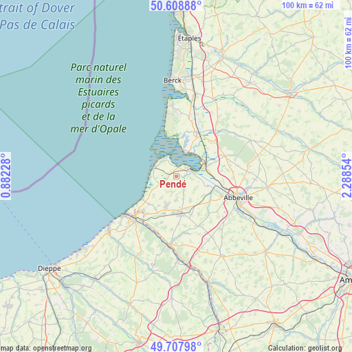
Pendé GPS coordinates[2]
50° 9' 37.98" North, 1° 35' 7.476" East
| Map corner | latitude | longitude |
|---|---|---|
| Upper-left | 50.60888°, | 0.88228° |
| Center: | 50.16055°, | 1.58541° |
| Lower-right: | 49.70798°, | 2.28854° |
| Map W x H: | 100.2×100.2 km | = 62.3×62.3mi |
| max Lat: | 51.07786° ⇑5.4% North |
| Pendé: | 50.16055° |
| min Lat: | ⇓94.6% South 41.3874° |
| min Long | Pendé | max Long |
| -5.08615° | 1.58541° | 9.52242° |
| W 38.1%⇐ | ⇒61.9% E |
Elevation
Elevation of Pendé is 7 m = 23 ft, and this is 186.7 m = 613 ft below average elevation for this country.
| Max E: |
2333 m = 7654 ft | 98.6% |
| Avg. | 193.7 m = 635 ft | |
| Pendé | 7 m = 23 ft | |
Min E: |
-1 m = -3 ft | 1.4% |
See also: France elevation on elevation.city.
Geographical zone
Pendé is located in North temperate zone (between Tropic of Cancer and the Arctic Circle). Distance of this North polar circle is 1823.8 km =1133.3 mi to North.| Distance of | km | miles | from Pendé |
|---|---|---|---|
| North Pole | 4429.7 | 2752.5 | to North |
| Arctic Circle | 1823.8 | 1133.3 | to North |
| Tropic Cancer | 2971.4 | 1846.3 | to South |
| Equator | 5577.3 | 3465.6 | to South |


Nearby cities:
15 places around Pendé: (largest is in red/bold)
• Arrest
3.9 km =2.4 mi,  147°
147°
• Belloy
8 km =5 mi,  203°
203°
• Boismont
7.2 km =4.5 mi,  97°
97°
• Bourseville
7.4 km =4.6 mi,  214°
214°
• Cayeux-sur-Mer
6.9 km =4.3 mi,  290°
290°
• Franleu
7.9 km =4.9 mi, 149°
• Friville-Escarbotin
8.8 km =5.5 mi, 198°
• Lanchères
2.2 km =1.4 mi,  265°
265°
• Le Crotoy
6.8 km =4.2 mi,  24°
24°
• Nibas
6.5 km =4 mi,  177°
177°
• Noyelles-sur-Mer
9.1 km =5.7 mi,  72°
72°
• Quesnoy-le-Montant
9.3 km =5.8 mi,  126°
126°
• Saint-Blimont
4.5 km =2.8 mi,  189°
189°
• Saint-Valery-sur-Somme
4.2 km =2.6 mi,  53°
53°
• Woignarue
8.5 km =5.3 mi,  228°
228°
Sources, notices
• [Note1] Compared only with cities in France existing in our database
• [Src1] Map data: © OpenStreetMap contributors (CC-BY-SA)
• [Src2] Other city data from geonames.org with taken over terms of usage.
• [Src3] Geographical zone / Annual Mean Temperature by Robert A. Rohde @ Wikipedia
