Saint-Valery-sur-Somme geodata
Saint-Valery-sur-Somme (Hauts-de-France) is a populated place; located in France in Europe/Paris (GMT+2) time zone. With population of 2,754 people, there are 3553 cities with bigger population in this country. Compared to other cities in France, 94.7% of cities are located further ↓South; 61.2% of cities are located further →East and 88.6% of cities have higher elevation than Saint-Valery-sur-Somme. Note1
Administrative division(s):
- Level 1: Hauts-de-France
- Level 2: Somme
- Level 3: Abbeville
- Level 4: Saint-Valery-sur-Somme
Current local time in Saint-Valery-sur-Somme:
07:23 AM, SaturdayDifference from your time zone: hours


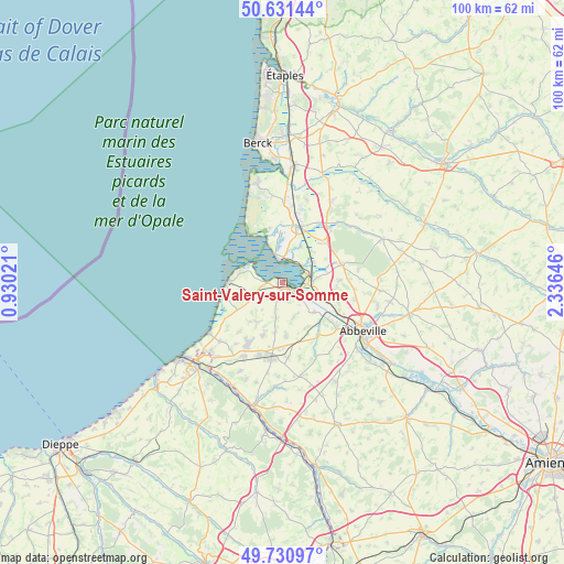
Saint-Valery-sur-Somme GPS coordinates[2]
50° 10' 59.988" North, 1° 37' 59.988" East
| Map corner | latitude | longitude |
|---|---|---|
| Upper-left | 50.63144°, | 0.93021° |
| Center: | 50.18333°, | 1.63333° |
| Lower-right: | 49.73097°, | 2.33646° |
| Map W x H: | 100.1×100.1 km | = 62.2×62.2mi |
| max Lat: | 51.07786° ⇑5.3% North |
| Saint-Valery-sur-Somme: | 50.18333° |
| min Lat: | ⇓94.7% South 41.3874° |
| min Long | Saint-Valery-su | max Long |
| -5.08615° | 1.63333° | 9.52242° |
| W 38.8%⇐ | ⇒61.2% E |
Elevation
Elevation of Saint-Valery-sur-Somme is 33 m = 108 ft, and this is 160.7 m = 527 ft below average elevation for this country.
| Max E: |
2333 m = 7654 ft | 88.6% |
| Avg. | 193.7 m = 635 ft | |
| Saint-Valery-sur-Somme | 33 m = 108 ft | |
Min E: |
-1 m = -3 ft | 11.4% |
See also: France elevation on elevation.city.
Geographical zone
Saint-Valery-sur-Somme is located in North temperate zone (between Tropic of Cancer and the Arctic Circle). Distance of this North polar circle is 1821.3 km =1131.7 mi to North.| Distance of | km | miles | from Saint-Valery-sur-Somme |
|---|---|---|---|
| North Pole | 4427.2 | 2750.9 | to North |
| Arctic Circle | 1821.3 | 1131.7 | to North |
| Tropic Cancer | 2973.9 | 1847.9 | to South |
| Equator | 5579.9 | 3467.2 | to South |


Nearby cities:
15 places around Saint-Valery-sur-Somme: (largest is in red/bold)
• Arrest
6 km =3.7 mi,  192°
192°
• Boismont
5.1 km =3.2 mi,  133°
133°
• Cayeux-sur-Mer
9.9 km =6.2 mi,  269°
269°
• Franleu
9.4 km =5.8 mi,  176°
176°
• Lanchères
6.2 km =3.9 mi,  244°
244°
• Le Crotoy
3.7 km =2.3 mi,  350°
350°
• Nibas
9.5 km =5.9 mi,  199°
199°
• Nouvion
10.8 km =6.7 mi,  80°
80°
• Noyelles-sur-Mer
5.3 km =3.3 mi,  87°
87°
• Pendé
4.2 km =2.6 mi,  233°
233°
• Ponthoile
6.5 km =4 mi,  57°
57°
• Quesnoy-le-Montant
9 km =5.6 mi,  153°
153°
• Rue
10.2 km =6.3 mi,  15°
15°
• Sailly-Flibeaucourt
9.9 km =6.2 mi, 89°
• Saint-Blimont
8.2 km =5.1 mi,  210°
210°
Sources, notices
• [Note1] Compared only with cities in France existing in our database
• [Src1] Map data: © OpenStreetMap contributors (CC-BY-SA)
• [Src2] Other city data from geonames.org with taken over terms of usage.
• [Src3] Geographical zone / Annual Mean Temperature by Robert A. Rohde @ Wikipedia
