Cayeux-sur-Mer geodata
Cayeux-sur-Mer (Hauts-de-France) is a populated place; located in France in Europe/Paris (GMT+2) time zone. With population of 2,820 people, there are 3456 cities with bigger population in this country. Compared to other cities in France, 94.7% of cities are located further ↓South; 63.1% of cities are located further →East and 98.2% of cities have higher elevation than Cayeux-sur-Mer. Note1
Administrative division(s):
- Level 1: Hauts-de-France
- Level 2: Somme
- Level 3: Abbeville
- Level 4: Cayeux-sur-Mer


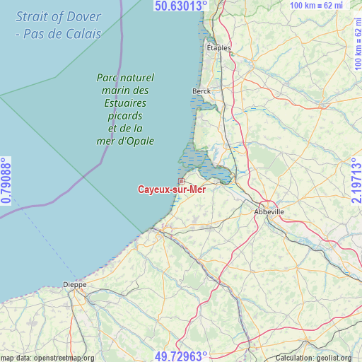
Cayeux-sur-Mer GPS coordinates[2]
50° 10' 55.2" North, 1° 29' 38.4" East
| Map corner | latitude | longitude |
|---|---|---|
| Upper-left | 50.63013°, | 0.79088° |
| Center: | 50.182°, | 1.494° |
| Lower-right: | 49.72963°, | 2.19713° |
| Map W x H: | 100.1×100.1 km | = 62.2×62.2mi |
| max Lat: | 51.07786° ⇑5.3% North |
| Cayeux-sur-Mer: | 50.182° |
| min Lat: | ⇓94.7% South 41.3874° |
| min Long | Cayeux-sur-Mer | max Long |
| -5.08615° | 1.494° | 9.52242° |
| W 36.9%⇐ | ⇒63.1% E |
Elevation
Elevation of Cayeux-sur-Mer is 8 m = 26 ft, and this is 185.7 m = 609 ft below average elevation for this country.
| Max E: |
2333 m = 7654 ft | 98.2% |
| Avg. | 193.7 m = 635 ft | |
| Cayeux-sur-Mer | 8 m = 26 ft | |
Min E: |
-1 m = -3 ft | 1.8% |
See also: France elevation on elevation.city.
Geographical zone
Cayeux-sur-Mer is located in North temperate zone (between Tropic of Cancer and the Arctic Circle). Distance of this North polar circle is 1821.5 km =1131.8 mi to North.| Distance of | km | miles | from Cayeux-sur-Mer |
|---|---|---|---|
| North Pole | 4427.3 | 2751 | to North |
| Arctic Circle | 1821.5 | 1131.8 | to North |
| Tropic Cancer | 2973.8 | 1847.8 | to South |
| Equator | 5579.7 | 3467.1 | to South |


Nearby cities:
15 places around Cayeux-sur-Mer: (largest is in red/bold)
• Arrest
10.4 km =6.5 mi,  123°
123°
• Ault
9.2 km =5.7 mi,  199°
199°
• Belloy
10.2 km =6.3 mi,  161°
161°
• Bourseville
8.8 km =5.5 mi, 164°
• Béthencourt-sur-Mer
11.6 km =7.2 mi,  176°
176°
• Friaucourt
10.4 km =6.5 mi,  186°
186°
• Friville-Escarbotin
11.3 km =7 mi, 160°
• Lanchères
5 km =3.1 mi, 120°
• Le Crotoy
10.1 km =6.3 mi,  67°
67°
• Nibas
11.1 km =6.9 mi,  142°
142°
• Pendé
6.9 km =4.3 mi,  110°
110°
• Saint-Blimont
8.9 km =5.5 mi, 140°
• Saint-Valery-sur-Somme
9.9 km =6.2 mi,  89°
89°
• Tully
10.8 km =6.7 mi,  171°
171°
• Woignarue
8 km =5 mi, 179°
Sources, notices
• [Note1] Compared only with cities in France existing in our database
• [Src1] Map data: © OpenStreetMap contributors (CC-BY-SA)
• [Src2] Other city data from geonames.org with taken over terms of usage.
• [Src3] Geographical zone / Annual Mean Temperature by Robert A. Rohde @ Wikipedia
