Parent geodata
Parent (Auvergne-Rhône-Alpes) is a populated place; located in France in Europe/Paris (GMT+2) time zone. With population of 681 people, there are 12056 cities with bigger population in this country. Compared to other cities in France, 72.2% of cities are located further ↑North; 61% of cities are located further ←West and 94.7% of cities have lower elevation than Parent. Note1
Administrative division(s):
- Level 1: Auvergne-Rhône-Alpes
- Level 2: Département du Puy-de-Dôme
- Level 3: Issoire
- Level 4: Parent


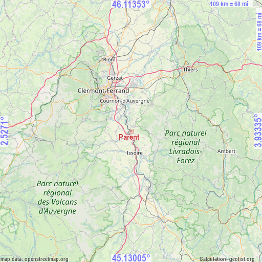
Parent GPS coordinates[2]
45° 37' 26.22" North, 3° 13' 48.792" East
| Map corner | latitude | longitude |
|---|---|---|
| Upper-left | 46.11353°, | 2.5271° |
| Center: | 45.62395°, | 3.23022° |
| Lower-right: | 45.13005°, | 3.93335° |
| Map W x H: | 109.4×109.4 km | = 68×68mi |
| max Lat: | 51.07786° ⇑72.2% North |
| Parent: | 45.62395° |
| min Lat: | ⇓27.8% South 41.3874° |
| min Long | Parent | max Long |
| -5.08615° | 3.23022° | 9.52242° |
| W 61%⇐ | ⇒39% E |
Elevation
Elevation of Parent is 568 m = 1864 ft, and this is 374.3 m = 1228 ft above average elevation for this country.
| Max E: |
2333 m = 7654 ft | 5.3% |
| Parent | 568 m 1864 ft | |
| Avg. | 193.7 m = 635 ft | |
Min E: |
-1 m = -3 ft | 94.7% |
See also: France elevation on elevation.city.
Geographical zone
Parent is located in North temperate zone (between Tropic of Cancer and the Arctic Circle). Distance of this North polar circle is 2328.3 km =1446.7 mi to North.| Distance of | km | miles | from Parent |
|---|---|---|---|
| North Pole | 4934.2 | 3066 | to North |
| Arctic Circle | 2328.3 | 1446.7 | to North |
| Tropic Cancer | 2467 | 1532.9 | to South |
| Equator | 5072.9 | 3152.2 | to South |


Nearby cities:
15 places around Parent: (largest is in red/bold)
• Authezat
3.6 km =2.2 mi,  283°
283°
• Champeix
8.8 km =5.5 mi,  243°
243°
• Corent
5.5 km =3.4 mi,  329°
329°
• Coudes
2 km =1.2 mi, 239°
• Issoire
9 km =5.6 mi,  170°
170°
• Laps
6.4 km =4 mi,  29°
29°
• Mirefleurs
7.7 km =4.8 mi,  356°
356°
• Neschers
6.4 km =4 mi,  234°
234°
• Orbeil
7.8 km =4.8 mi,  151°
151°
• Plauzat
6.3 km =3.9 mi,  267°
267°
• Saint-Babel
6.2 km =3.9 mi,  119°
119°
• Saint-Maurice
5.2 km =3.2 mi,  5°
5°
• Veyre-Monton
6.8 km =4.2 mi,  317°
317°
• Vic-le-Comte
2.4 km =1.5 mi, 30°
• Yronde
2.3 km =1.4 mi, 121°
Sources, notices
• [Note1] Compared only with cities in France existing in our database
• [Src1] Map data: © OpenStreetMap contributors (CC-BY-SA)
• [Src2] Other city data from geonames.org with taken over terms of usage.
• [Src3] Geographical zone / Annual Mean Temperature by Robert A. Rohde @ Wikipedia
