Mirefleurs geodata
Mirefleurs (Auvergne-Rhône-Alpes) is a populated place; located in France in Europe/Paris (GMT+2) time zone. With population of 1,887 people, there are 5056 cities with bigger population in this country. Compared to other cities in France, 71% of cities are located further ↑North; 60.9% of cities are located further ←West and 88.5% of cities have lower elevation than Mirefleurs. Note1
Administrative division(s):
- Level 1: Auvergne-Rhône-Alpes
- Level 2: Département du Puy-de-Dôme
- Level 3: Arrondissement de Clermont-Ferrand
- Level 4: Mirefleurs


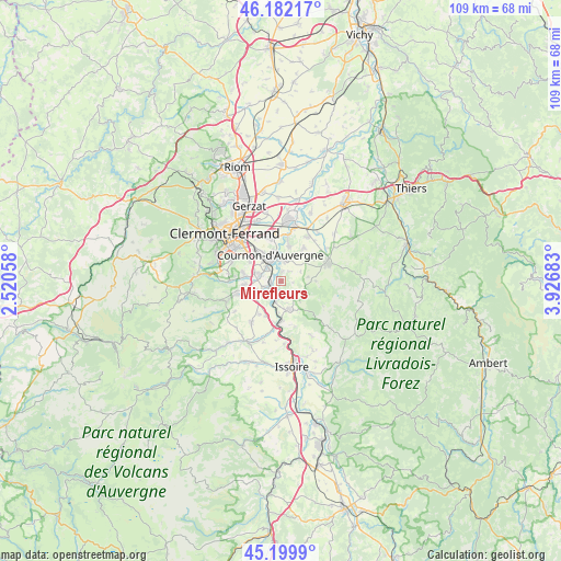
Mirefleurs GPS coordinates[2]
45° 41' 35.484" North, 3° 13' 25.32" East
| Map corner | latitude | longitude |
|---|---|---|
| Upper-left | 46.18217°, | 2.52058° |
| Center: | 45.69319°, | 3.2237° |
| Lower-right: | 45.1999°, | 3.92683° |
| Map W x H: | 109.2×109.2 km | = 67.9×67.9mi |
| max Lat: | 51.07786° ⇑71% North |
| Mirefleurs: | 45.69319° |
| min Lat: | ⇓29% South 41.3874° |
| min Long | Mirefleurs | max Long |
| -5.08615° | 3.2237° | 9.52242° |
| W 60.9%⇐ | ⇒39.1% E |
Elevation
Elevation of Mirefleurs is 396 m = 1299 ft, and this is 202.3 m = 664 ft above average elevation for this country.
| Max E: |
2333 m = 7654 ft | 11.5% |
| Mirefleurs | 396 m 1299 ft | |
| Avg. | 193.7 m = 635 ft | |
Min E: |
-1 m = -3 ft | 88.5% |
See also: France elevation on elevation.city.
Geographical zone
Mirefleurs is located in North temperate zone (between Tropic of Cancer and the Arctic Circle). Distance of this North polar circle is 2320.6 km =1442 mi to North.| Distance of | km | miles | from Mirefleurs |
|---|---|---|---|
| North Pole | 4926.5 | 3061.2 | to North |
| Arctic Circle | 2320.6 | 1442 | to North |
| Tropic Cancer | 2474.7 | 1537.7 | to South |
| Equator | 5080.6 | 3156.9 | to South |


Nearby cities:
15 places around Mirefleurs: (largest is in red/bold)
• Authezat
7.5 km =4.7 mi,  203°
203°
• Corent
3.7 km =2.3 mi,  217°
217°
• Cournon-d’Auvergne
5.7 km =3.5 mi,  338°
338°
• La Roche-Blanche
7.6 km =4.7 mi,  276°
276°
• Laps
4.2 km =2.6 mi,  120°
120°
• Le Cendre
4.3 km =2.7 mi,  318°
318°
• Le Crest
7.5 km =4.7 mi,  264°
264°
• Mezel
7 km =4.3 mi,  11°
11°
• Orcet
4.4 km =2.7 mi,  285°
285°
• Pérignat-sur-Allier
4 km =2.5 mi, 9°
• Saint-Georges-sur-Allier
2.4 km =1.5 mi,  37°
37°
• Saint-Julien-de-Coppel
6.7 km =4.2 mi,  88°
88°
• Saint-Maurice
2.7 km =1.7 mi,  158°
158°
• Veyre-Monton
4.9 km =3 mi,  236°
236°
• Vic-le-Comte
5.8 km =3.6 mi, 162°
Sources, notices
• [Note1] Compared only with cities in France existing in our database
• [Src1] Map data: © OpenStreetMap contributors (CC-BY-SA)
• [Src2] Other city data from geonames.org with taken over terms of usage.
• [Src3] Geographical zone / Annual Mean Temperature by Robert A. Rohde @ Wikipedia
