Panazol geodata
Panazol (Nouvelle-Aquitaine) is a populated place; located in France in Europe/Paris (GMT+2) time zone. With population of 10,055 people, there are 948 cities with bigger population in this country. Compared to other cities in France, 68.6% of cities are located further ↑North; 65.4% of cities are located further →East and 81.7% of cities have lower elevation than Panazol. Note1
Administrative division(s):
- Level 1: Nouvelle-Aquitaine
- Level 2: Haute-Vienne
- Level 3: Arrondissement de Limoges
- Level 4: Panazol


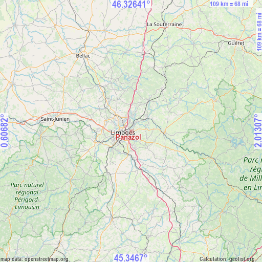
Panazol GPS coordinates[2]
45° 50' 19.356" North, 1° 18' 35.82" East
| Map corner | latitude | longitude |
|---|---|---|
| Upper-left | 46.32641°, | 0.60682° |
| Center: | 45.83871°, | 1.30995° |
| Lower-right: | 45.3467°, | 2.01307° |
| Map W x H: | 108.9×108.9 km | = 67.7×67.7mi |
| max Lat: | 51.07786° ⇑68.6% North |
| Panazol: | 45.83871° |
| min Lat: | ⇓31.4% South 41.3874° |
| min Long | Panazol | max Long |
| -5.08615° | 1.30995° | 9.52242° |
| W 34.6%⇐ | ⇒65.4% E |
Elevation
Elevation of Panazol is 308 m = 1010 ft, and this is 114.3 m = 375 ft above average elevation for this country.
| Max E: |
2333 m = 7654 ft | 18.3% |
| Panazol | 308 m 1010 ft | |
| Avg. | 193.7 m = 635 ft | |
Min E: |
-1 m = -3 ft | 81.7% |
See also: France elevation on elevation.city.
Geographical zone
Panazol is located in North temperate zone (between Tropic of Cancer and the Arctic Circle). Distance of this North polar circle is 2304.4 km =1431.9 mi to North.| Distance of | km | miles | from Panazol |
|---|---|---|---|
| North Pole | 4910.3 | 3051.1 | to North |
| Arctic Circle | 2304.4 | 1431.9 | to North |
| Tropic Cancer | 2490.9 | 1547.8 | to South |
| Equator | 5096.8 | 3167 | to South |


Nearby cities:
15 places around Panazol: (largest is in red/bold)
• Aureil
7.3 km =4.5 mi,  119°
119°
• Boisseuil
7.8 km =4.8 mi,  167°
167°
• Chaptelat
8.9 km =5.5 mi,  333°
333°
• Condat-sur-Vienne
7.9 km =4.9 mi,  230°
230°
• Couzeix
6.9 km =4.3 mi,  307°
307°
• Eyjeaux
9.4 km =5.8 mi,  137°
137°
• Feytiat
3.6 km =2.2 mi,  152°
152°
• Isle
7.5 km =4.7 mi,  239°
239°
• Le Palais-sur-Vienne
3 km =1.9 mi,  20°
20°
• Le Vigen
9.8 km =6.1 mi,  189°
189°
• Limoges
4.9 km =3 mi,  263°
263°
• Rilhac-Rancon
6.6 km =4.1 mi,  5°
5°
• Saint-Just-le-Martel
6.5 km =4 mi,  65°
65°
• Saint-Priest-Taurion
8.8 km =5.5 mi,  52°
52°
• Solignac
9.7 km =6 mi,  196°
196°
Sources, notices
• [Note1] Compared only with cities in France existing in our database
• [Src1] Map data: © OpenStreetMap contributors (CC-BY-SA)
• [Src2] Other city data from geonames.org with taken over terms of usage.
• [Src3] Geographical zone / Annual Mean Temperature by Robert A. Rohde @ Wikipedia
