Le Palais-sur-Vienne geodata
Le Palais-sur-Vienne (Nouvelle-Aquitaine) is a populated place; located in France in Europe/Paris (GMT+2) time zone. With population of 5,944 people, there are 1661 cities with bigger population in this country. Compared to other cities in France, 68.3% of cities are located further ↑North; 65.3% of cities are located further →East and 78.3% of cities have lower elevation than Le Palais-sur-Vienne. Note1
Administrative division(s):
- Level 1: Nouvelle-Aquitaine
- Level 2: Haute-Vienne
- Level 3: Arrondissement de Limoges
- Level 4: Le Palais-sur-Vienne


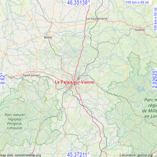
Le Palais-sur-Vienne GPS coordinates[2]
45° 51' 50.04" North, 1° 19' 23.268" East
| Map corner | latitude | longitude |
|---|---|---|
| Upper-left | 46.35138°, | 0.62° |
| Center: | 45.8639°, | 1.32313° |
| Lower-right: | 45.37211°, | 2.02625° |
| Map W x H: | 108.9×108.9 km | = 67.7×67.7mi |
| max Lat: | 51.07786° ⇑68.3% North |
| Le Palais-sur-Vienne: | 45.8639° |
| min Lat: | ⇓31.7% South 41.3874° |
| min Long | Le Palais-sur-V | max Long |
| -5.08615° | 1.32313° | 9.52242° |
| W 34.7%⇐ | ⇒65.3% E |
Elevation
Elevation of Le Palais-sur-Vienne is 274 m = 899 ft, and this is 80.3 m = 263 ft above average elevation for this country.
| Max E: |
2333 m = 7654 ft | 21.7% |
| Le Palais-sur-Vienne | 274 m 899 ft | |
| Avg. | 193.7 m = 635 ft | |
Min E: |
-1 m = -3 ft | 78.3% |
See also: France elevation on elevation.city.
Geographical zone
Le Palais-sur-Vienne is located in North temperate zone (between Tropic of Cancer and the Arctic Circle). Distance of this North polar circle is 2301.6 km =1430.1 mi to North.| Distance of | km | miles | from Le Palais-sur-Vienne |
|---|---|---|---|
| North Pole | 4907.5 | 3049.4 | to North |
| Arctic Circle | 2301.6 | 1430.1 | to North |
| Tropic Cancer | 2493.7 | 1549.5 | to South |
| Equator | 5099.6 | 3168.7 | to South |


Nearby cities:
15 places around Le Palais-sur-Vienne: (largest is in red/bold)
• Aureil
8.4 km =5.2 mi,  140°
140°
• Boisseuil
10.5 km =6.5 mi,  176°
176°
• Bonnac-la-Côte
9.1 km =5.7 mi,  340°
340°
• Chaptelat
7.2 km =4.5 mi,  315°
315°
• Condat-sur-Vienne
10.6 km =6.6 mi,  222°
222°
• Couzeix
6.7 km =4.2 mi,  282°
282°
• Eyjeaux
11.1 km =6.9 mi,  151°
151°
• Feytiat
6 km =3.7 mi,  174°
174°
• Isle
10 km =6.2 mi,  228°
228°
• Limoges
6.8 km =4.2 mi,  240°
240°
• Panazol
3 km =1.9 mi,  200°
200°
• Rilhac-Rancon
3.8 km =2.4 mi,  353°
353°
• Royères
8.8 km =5.5 mi,  95°
95°
• Saint-Just-le-Martel
4.9 km =3 mi,  91°
91°
• Saint-Priest-Taurion
6.5 km =4 mi,  66°
66°
Sources, notices
• [Note1] Compared only with cities in France existing in our database
• [Src1] Map data: © OpenStreetMap contributors (CC-BY-SA)
• [Src2] Other city data from geonames.org with taken over terms of usage.
• [Src3] Geographical zone / Annual Mean Temperature by Robert A. Rohde @ Wikipedia
