Orval geodata
Orval (Normandy) is a populated place; located in France in Europe/Paris (GMT+2) time zone. With population of 836 people, there are 10228 cities with bigger population in this country. Compared to other cities in France, 80% of cities are located further ↓South; 92.1% of cities are located further →East and 80.2% of cities have higher elevation than Orval. Note1
Administrative division(s):
- Level 1: Normandy
- Level 2: Manche
- Level 3: Arrondissement de Coutances
- Level 4: Orval sur Sienne


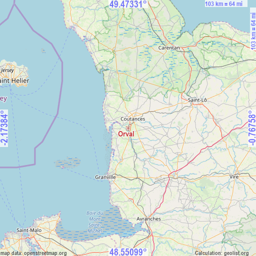
Orval GPS coordinates[2]
49° 0' 51.444" North, 1° 28' 14.556" West
| Map corner | latitude | longitude |
|---|---|---|
| Upper-left | 49.47331°, | -2.17384° |
| Center: | 49.01429°, | -1.47071° |
| Lower-right: | 48.55099°, | -0.76758° |
| Map W x H: | 102.6×102.6 km | = 63.8×63.8mi |
| max Lat: | 51.07786° ⇑20% North |
| Orval: | 49.01429° |
| min Lat: | ⇓80% South 41.3874° |
| min Long | Orval | max Long |
| -5.08615° | -1.47071° | 9.52242° |
| W 7.9%⇐ | ⇒92.1% E |
Elevation
Elevation of Orval is 54 m = 177 ft, and this is 139.7 m = 458 ft below average elevation for this country.
| Max E: |
2333 m = 7654 ft | 80.2% |
| Avg. | 193.7 m = 635 ft | |
| Orval | 54 m = 177 ft | |
Min E: |
-1 m = -3 ft | 19.8% |
See also: France elevation on elevation.city.
Geographical zone
Orval is located in North temperate zone (between Tropic of Cancer and the Arctic Circle). Distance of this North polar circle is 1951.3 km =1212.5 mi to North.| Distance of | km | miles | from Orval |
|---|---|---|---|
| North Pole | 4557.2 | 2831.7 | to North |
| Arctic Circle | 1951.3 | 1212.5 | to North |
| Tropic Cancer | 2844 | 1767.2 | to South |
| Equator | 5449.9 | 3386.4 | to South |


Nearby cities:
15 places around Orval: (largest is in red/bold)
• Annoville
7.2 km =4.5 mi,  221°
221°
• Bricqueville-la-Blouette
2.3 km =1.4 mi,  344°
344°
• Coutances
3.9 km =2.4 mi,  28°
28°
• Gratot
6.1 km =3.8 mi,  352°
352°
• Hauteville-sur-Mer
6.6 km =4.1 mi,  231°
231°
• Heugueville-sur-Sienne
4.9 km =3 mi,  309°
309°
• Lingreville
8.1 km =5 mi,  210°
210°
• Monthuchon
8.1 km =5 mi,  24°
24°
• Montmartin-sur-Mer
4.9 km =3 mi, 234°
• Quettreville-sur-Sienne
5.1 km =3.2 mi,  177°
177°
• Regnéville-sur-Mer
5.9 km =3.7 mi,  264°
264°
• Saint-Denis-le-Vêtu
5.8 km =3.6 mi,  122°
122°
• Saussey
2.8 km =1.7 mi,  101°
101°
• Tourville-sur-Sienne
6.7 km =4.2 mi,  301°
301°
• Trelly
6.8 km =4.2 mi,  152°
152°
Sources, notices
• [Note1] Compared only with cities in France existing in our database
• [Src1] Map data: © OpenStreetMap contributors (CC-BY-SA)
• [Src2] Other city data from geonames.org with taken over terms of usage.
• [Src3] Geographical zone / Annual Mean Temperature by Robert A. Rohde @ Wikipedia
