Coutances geodata
Coutances (Normandy) is a seat of a third-order administrative division; located in France in Europe/Paris (GMT+2) time zone. With population of 9,657 people, there are 986 cities with bigger population in this country. Compared to other cities in France, 80.8% of cities are located further ↓South; 91.9% of cities are located further →East and 79.4% of cities have higher elevation than Coutances. Note1
Administrative division(s):
- Level 1: Normandy
- Level 2: Manche
- Level 3: Arrondissement de Coutances
- Level 4: Coutances


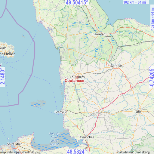
Coutances GPS coordinates[2]
49° 2' 43.476" North, 1° 26' 42.648" West
| Map corner | latitude | longitude |
|---|---|---|
| Upper-left | 49.50415°, | -2.1483° |
| Center: | 49.04541°, | -1.44518° |
| Lower-right: | 48.5824°, | -0.74205° |
| Map W x H: | 102.5×102.5 km | = 63.7×63.7mi |
| max Lat: | 51.07786° ⇑19.2% North |
| Coutances: | 49.04541° |
| min Lat: | ⇓80.8% South 41.3874° |
| min Long | Coutances | max Long |
| -5.08615° | -1.44518° | 9.52242° |
| W 8.1%⇐ | ⇒91.9% E |
Elevation
Elevation of Coutances is 56 m = 184 ft, and this is 137.7 m = 452 ft below average elevation for this country.
| Max E: |
2333 m = 7654 ft | 79.4% |
| Avg. | 193.7 m = 635 ft | |
| Coutances | 56 m = 184 ft | |
Min E: |
-1 m = -3 ft | 20.6% |
See also: France elevation on elevation.city.
Geographical zone
Coutances is located in North temperate zone (between Tropic of Cancer and the Arctic Circle). Distance of this North polar circle is 1947.8 km =1210.3 mi to North.| Distance of | km | miles | from Coutances |
|---|---|---|---|
| North Pole | 4553.7 | 2829.5 | to North |
| Arctic Circle | 1947.8 | 1210.3 | to North |
| Tropic Cancer | 2847.4 | 1769.3 | to South |
| Equator | 5453.3 | 3388.5 | to South |


Nearby cities:
15 places around Coutances: (largest is in red/bold)
• Agon-Coutainville
9.5 km =5.9 mi,  267°
267°
• Bricqueville-la-Blouette
2.8 km =1.7 mi,  242°
242°
• Cambernon
5.8 km =3.6 mi,  48°
48°
• Gratot
3.7 km =2.3 mi,  314°
314°
• Heugueville-sur-Sienne
5.7 km =3.5 mi, 266°
• Monthuchon
4.2 km =2.6 mi,  21°
21°
• Montmartin-sur-Mer
8.6 km =5.3 mi,  222°
222°
• Muneville-le-Bingard
8.7 km =5.4 mi,  343°
343°
• Orval
3.9 km =2.4 mi,  208°
208°
• Quettreville-sur-Sienne
8.8 km =5.5 mi,  190°
190°
• Regnéville-sur-Mer
8.7 km =5.4 mi, 242°
• Saint-Denis-le-Vêtu
7.2 km =4.5 mi,  155°
155°
• Saussey
4.1 km =2.5 mi,  167°
167°
• Tourville-sur-Sienne
7.5 km =4.7 mi, 270°
• Trelly
9.6 km =6 mi, 171°
Sources, notices
• [Note1] Compared only with cities in France existing in our database
• [Src1] Map data: © OpenStreetMap contributors (CC-BY-SA)
• [Src2] Other city data from geonames.org with taken over terms of usage.
• [Src3] Geographical zone / Annual Mean Temperature by Robert A. Rohde @ Wikipedia
