Notre-Dame-de-Gravenchon geodata
Notre-Dame-de-Gravenchon (Normandy) is a populated place; located in France in Europe/Paris (GMT+2) time zone. With population of 8,839 people, there are 1087 cities with bigger population in this country. Compared to other cities in France, 89.1% of cities are located further ↓South; 72.7% of cities are located further →East and 93.1% of cities have higher elevation than Notre-Dame-de-Gravenchon. Note1
Administrative division(s):
- Level 1: Normandy
- Level 2: Seine-Maritime
- Level 3: Arrondissement du Havre
- Level 4: Port-Jérôme-sur-Seine
Current local time in Notre-Dame-de-Gravenchon:
01:42 PM, WednesdayDifference from your time zone: hours


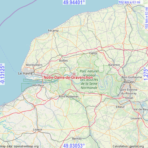
Notre-Dame-de-Gravenchon GPS coordinates[2]
49° 29' 21.84" North, 0° 34' 18.768" East
| Map corner | latitude | longitude |
|---|---|---|
| Upper-left | 49.94401°, | -0.13125° |
| Center: | 49.4894°, | 0.57188° |
| Lower-right: | 49.03053°, | 1.275° |
| Map W x H: | 101.6×101.6 km | = 63.1×63.1mi |
| max Lat: | 51.07786° ⇑10.9% North |
| Notre-Dame-de-Gravenchon: | 49.4894° |
| min Lat: | ⇓89.1% South 41.3874° |
| min Long | Notre-Dame-de-G | max Long |
| -5.08615° | 0.57188° | 9.52242° |
| W 27.3%⇐ | ⇒72.7% E |
Elevation
Elevation of Notre-Dame-de-Gravenchon is 22 m = 72 ft, and this is 171.7 m = 563 ft below average elevation for this country.
| Max E: |
2333 m = 7654 ft | 93.1% |
| Avg. | 193.7 m = 635 ft | |
| Notre-Dame-de-Gravenchon | 22 m = 72 ft | |
Min E: |
-1 m = -3 ft | 6.9% |
See also: France elevation on elevation.city.
Geographical zone
Notre-Dame-de-Gravenchon is located in North temperate zone (between Tropic of Cancer and the Arctic Circle). Distance of this North polar circle is 1898.5 km =1179.7 mi to North.| Distance of | km | miles | from Notre-Dame-de-Gravenchon |
|---|---|---|---|
| North Pole | 4504.4 | 2798.9 | to North |
| Arctic Circle | 1898.5 | 1179.7 | to North |
| Tropic Cancer | 2896.8 | 1800 | to South |
| Equator | 5502.7 | 3419.2 | to South |


Nearby cities:
15 places around Notre-Dame-de-Gravenchon: (largest is in red/bold)
• Auberville-la-Campagne
5.3 km =3.3 mi,  22°
22°
• Grand-Camp
6.8 km =4.2 mi,  6°
6°
• La Trinité-du-Mont
6.1 km =3.8 mi,  347°
347°
• Lillebonne
4.3 km =2.7 mi,  323°
323°
• Norville
5.2 km =3.2 mi,  103°
103°
• Petiville
3.4 km =2.1 mi,  160°
160°
• Quillebeuf-sur-Seine
3.9 km =2.4 mi,  234°
234°
• Saint-Antoine-la-Forêt
8.8 km =5.5 mi,  306°
306°
• Saint-Arnoult
8.3 km =5.2 mi,  59°
59°
• Saint-Jean-de-Folleville
6 km =3.7 mi, 306°
• Saint-Nicolas-de-la-Taille
7.5 km =4.7 mi,  288°
288°
• Tancarville
8.3 km =5.2 mi,  266°
266°
• Trouville-la-Haule
7.8 km =4.8 mi,  176°
176°
• Vatteville-la-Rue
8.1 km =5 mi,  81°
81°
• Villequier
7.8 km =4.8 mi,  70°
70°
Sources, notices
• [Note1] Compared only with cities in France existing in our database
• [Src1] Map data: © OpenStreetMap contributors (CC-BY-SA)
• [Src2] Other city data from geonames.org with taken over terms of usage.
• [Src3] Geographical zone / Annual Mean Temperature by Robert A. Rohde @ Wikipedia
