Lillebonne geodata
Lillebonne (Normandy) is a populated place; located in France in Europe/Paris (GMT+2) time zone. With population of 9,797 people, there are 971 cities with bigger population in this country. Compared to other cities in France, 89.6% of cities are located further ↓South; 73.1% of cities are located further →East and 95.7% of cities have higher elevation than Lillebonne. Note1
Administrative division(s):
- Level 1: Normandy
- Level 2: Seine-Maritime
- Level 3: Arrondissement du Havre
- Level 4: Lillebonne


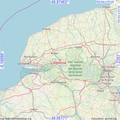
Lillebonne GPS coordinates[2]
49° 31' 13.08" North, 0° 32' 10.212" East
| Map corner | latitude | longitude |
|---|---|---|
| Upper-left | 49.97463°, | -0.16696° |
| Center: | 49.5203°, | 0.53617° |
| Lower-right: | 49.06171°, | 1.2393° |
| Map W x H: | 101.5×101.5 km | = 63.1×63.1mi |
| max Lat: | 51.07786° ⇑10.4% North |
| Lillebonne: | 49.5203° |
| min Lat: | ⇓89.6% South 41.3874° |
| min Long | Lillebonne | max Long |
| -5.08615° | 0.53617° | 9.52242° |
| W 26.9%⇐ | ⇒73.1% E |
Elevation
Elevation of Lillebonne is 15 m = 49 ft, and this is 178.7 m = 586 ft below average elevation for this country.
| Max E: |
2333 m = 7654 ft | 95.7% |
| Avg. | 193.7 m = 635 ft | |
| Lillebonne | 15 m = 49 ft | |
Min E: |
-1 m = -3 ft | 4.3% |
See also: France elevation on elevation.city.
Geographical zone
Lillebonne is located in North temperate zone (between Tropic of Cancer and the Arctic Circle). Distance of this North polar circle is 1895 km =1177.5 mi to North.| Distance of | km | miles | from Lillebonne |
|---|---|---|---|
| North Pole | 4500.9 | 2796.7 | to North |
| Arctic Circle | 1895 | 1177.5 | to North |
| Tropic Cancer | 2900.2 | 1802.1 | to South |
| Equator | 5506.1 | 3421.3 | to South |


Nearby cities:
15 places around Lillebonne: (largest is in red/bold)
• Auberville-la-Campagne
4.8 km =3 mi,  72°
72°
• Beuzevillette
5.7 km =3.5 mi,  0°
0°
• Grand-Camp
4.7 km =2.9 mi,  45°
45°
• Gruchet-le-Valasse
5.2 km =3.2 mi,  317°
317°
• La Trinité-du-Mont
2.8 km =1.7 mi,  25°
25°
• Lanquetot
7.3 km =4.5 mi,  354°
354°
• Mélamare
6.1 km =3.8 mi,  287°
287°
• Notre-Dame-de-Gravenchon
4.3 km =2.7 mi,  143°
143°
• Quillebeuf-sur-Seine
5.7 km =3.5 mi,  185°
185°
• Saint-Antoine-la-Forêt
4.8 km =3 mi, 291°
• Saint-Eustache-la-Forêt
6.7 km =4.2 mi,  300°
300°
• Saint-Jean-de-Folleville
2.2 km =1.4 mi,  273°
273°
• Saint-Nicolas-de-la-Taille
4.6 km =2.9 mi,  256°
256°
• Tancarville
6.9 km =4.3 mi,  235°
235°
• Trouville
7.4 km =4.6 mi,  38°
38°
Sources, notices
• [Note1] Compared only with cities in France existing in our database
• [Src1] Map data: © OpenStreetMap contributors (CC-BY-SA)
• [Src2] Other city data from geonames.org with taken over terms of usage.
• [Src3] Geographical zone / Annual Mean Temperature by Robert A. Rohde @ Wikipedia
